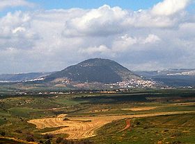
Mount Tabor, Israel
| Mount Tabor | |
|---|---|
 |
|
| Highest point | |
| Elevation | 575 m (1,886 ft) |
| Coordinates | 32°41′13.61″N 35°23′25.38″E / 32.6871139°N 35.3903833°ECoordinates: 32°41′13.61″N 35°23′25.38″E / 32.6871139°N 35.3903833°E |
| Geography | |
Mount Tabor (Hebrew: הר תבור, Modern Har Tavor, Tiberian Har Tāḇôr, Arabic: جبل الطور, Jabal aṭ-Ṭūr Latin: Itabyrium, Koine Greek: Όρος Θαβώρ) is located in Lower Galilee, Israel, at the eastern end of the Jezreel Valley, 11 miles (18 km) west of the Sea of Galilee. It was the site of the Mount Tabor battle between Barak under the leadership of the Israelite judge Deborah, and the army of Jabin commanded by Sisera, in the mid 12th century BCE. It is believed by many Christians to be the site of the Transfiguration of Jesus. It is known as Har Tavor in Hebrew, Itabyrium in the Graeco-Roman world, Jebel et-Tur in Arabic, and the Mount of Transfiguration in Christian context.
Mount Tabor is shaped almost like a half-sphere, suddenly rising from rather flat surroundings and reaching a height of 575 metres (1,886 feet), thus dominating by a good 450 metres the next town in the plain below, Kfar Tavor. The Catholic church at the top is well visible from afar. At the base it is almost fully surrounded by the Arab villages of Daburiyya, Shibli, and Umm al-Ghanam.
...
Wikipedia

