Mount Pocono, Pennsylvania
| Borough of Mount Pocono | |
| Settlement | |
|
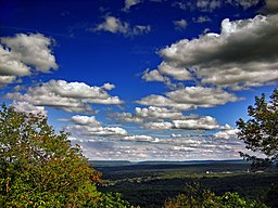
Mount Pocono Lookout, looking east toward Delaware Water Gap.
|
|
| Country | United States |
|---|---|
| State | Pennsylvania |
| County | Monroe |
| Elevation | 1,988 ft (605.9 m) |
| Coordinates | 41°07′23″N 75°21′34″W / 41.12306°N 75.35944°WCoordinates: 41°07′23″N 75°21′34″W / 41.12306°N 75.35944°W |
| Area | 3.5 sq mi (9.1 km2) |
| - land | 3.5 sq mi (9 km2) |
| - water | 0.0 sq mi (0 km2), 0% |
| Population | 3,170 (2010) |
| Density | 792.2/sq mi (305.9/km2) |
| Mayor | Frederick T. Courtright (D) |
| Timezone | EST (UTC-5) |
| - summer (DST) | EDT (UTC-4) |
| ZIP Code | 18344 |
| Area code | 570 Exchange: 839 |
|
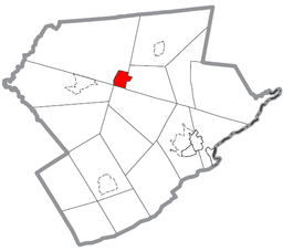
Location of Mount Pocono in Monroe County
|
|
|
Website: mountpocono-pa |
|
Mount Pocono is a borough in Monroe County, Pennsylvania, in the United States. It is located nearly centered in the southernmost county of five in the northeast corner that are part of the Poconos Mountains region of the state. The town serves as a local highway nexus, and as such sees a lot of tourist traffic making use of resources in the region.
As of the 2010 census, the borough population was 3,170 residents.
The town of Mount Pocono is located at 41°7′23″N 75°21′34″W / 41.12306°N 75.35944°W (41.123012, −75.359574), and is nearly centered in Monroe County — the most southerly and centered county of the five counties containing portions of the Pocono Mountains of Northeastern Pennsylvania. The region's valleys includes left bank tributaries of the Lehigh River in the southern half, and as the mountain ranges narrow closer to New York, are instead drained by left bank tributaries of the Susquehanna River. To the east, all Poconos ridge lines drain into the Delaware River or right bank tributaries of the Delaware.
According to the United States Census Bureau, the borough has a total area of 3.5 square miles (9.0 km2), all of it land.
...
Wikipedia


