Monroe County, Pennsylvania
| Monroe County, Pennsylvania | |
|---|---|

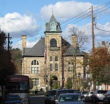
Monroe County Courthouse
|
|
 Location in the U.S. state of Pennsylvania |
|
 Pennsylvania's location in the U.S. |
|
| Founded | April 1, 1836 |
| Named for | James Monroe |
| Seat | Stroudsburg |
| Largest borough | East Stroudsburg |
| Area | |
| • Total | 617 sq mi (1,598 km2) |
| • Land | 608 sq mi (1,575 km2) |
| • Water | 9.0 sq mi (23 km2), 1.5% |
| Population (est.) | |
| • (2015) | 166,397 |
| • Density | 274/sq mi (106/km²) |
| Congressional districts | 10th, 17th |
| Time zone | Eastern: UTC-5/-4 |
| Website | Monroe County, Pennsylvania |
Monroe County is a county in the U.S. state of Pennsylvania. As of the 2010 census, the population was 169,842. Its county seat is Stroudsburg. The county was formed from the northern section of Northampton County. Named in honor of James Monroe, the fifth president of the United States, the county is located in northeastern Pennsylvania, along its border with New Jersey. Monroe County is coterminous with the East Stroudsburg, PA Metropolitan Statistical Area, within the Greater New York-Newark, NY-NJ-CT-PA Combined Statistical Area.
The county is home to East Stroudsburg University. Monroe County is one of the fastest-growing counties in the state of Pennsylvania. Not only has the population increased by over 70% since 1990, but the commercial and retail sectors have grown significantly, as well. There are many new shopping centers, and even more are being constructed and are currently being planned at this time.
According to the U.S. Census Bureau, the county has a total area of 617 square miles (1,600 km2), of which 608 square miles (1,570 km2) is land and 9.0 square miles (23 km2) (1.5%) is water.
As of the census of 2010, there were 169,842 people, 49,454 households, and 36,447 families residing in the county. The population density was 228 people per square mile (88/km²). There were 67,581 housing units at an average density of 111 per square mile (43/km²). The racial makeup of the county was 70.5% White Non-Hispanic, 13.2% Black or African American, 0.3% Native American, 2.1% Asian, 0.03% Pacific Islander, 4.3% from other races, and 2.9% from two or more races. 13.1% of the population were Hispanic or Latino of any race. 19.9% were of German, 16.8% Irish, 14.5% Italian, 8.8% Pennsylvania German, 5.4% Polish, 5.1% American and 5.1% English ancestry according to Census 2000.
...
Wikipedia
