Mount Lindesay (Queensland)
| Mount Lindesay | |
|---|---|

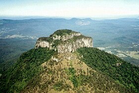
The distinctly shaped peak of Mount Lindesay
|
|
| Highest point | |
| Elevation | 1,177 m (3,862 ft) |
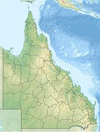
| Coordinates | 28°20′40″S 152°43′21″E / 28.34444°S 152.72250°ECoordinates: 28°20′40″S 152°43′21″E / 28.34444°S 152.72250°E |
| Geography | |
| Parent range | McPherson Range |
| Climbing | |
| First ascent | 1872 |
Mount Lindesay is a mountain and locality within the Scenic Rim Region, Queensland, Australia.
The mountain lies on the Queensland-New South Wales border, approximately 140 km south west of Brisbane, Australia. It is one of a number of peaks in the McPherson Range, and is remarkable for its tiered summit, the eroded remnant of lava flows from the nearby Focal Peak shield volcano. Mount Lindesay is situated within the Mount Barney National Park in Queensland and the Border Ranges National Park in New South Wales. Apart from the northern slopes, the rest of the peak is covered in dense rainforest, and the summit is frequently in cloud and mist. The Mount Lindesay Highway passes to the western side of Mount Lindesay.
On 6 July 1828, the botanist and explorer Allan Cunningham originally named this mountain Mount Hooker after botanist William Hooker and called another mountain (now Mount Barney) by the name Mount Lindesay after Colonel Patrick Lindesay, the Commandant of Troops in New South Wales 1827-1836. Later, the New South Wales Surveyor-General Thomas Mitchell is believed to have changed the names to be Mount Lindesay and Mount Barney (after Lieutenant-Colonel George Barney) respectively.
The first recorded ascent of Mount Lindesay by Europeans was made in May 1872, by Thomas de Montmorency Murray-Prior (1848-1902) and Phillip Walter Pears (1846-1924). At the time of the 1872 ascent, an Aboriginal elder at nearby Unumgar station informed Pears that his father had once climbed the peak, which suggests that Aboriginal people have made occasional ascents of Mount Lindesay for thousands of years.
...
Wikipedia

