Scenic Rim Region
|
Scenic Rim Region Queensland |
|||||||||||||
|---|---|---|---|---|---|---|---|---|---|---|---|---|---|

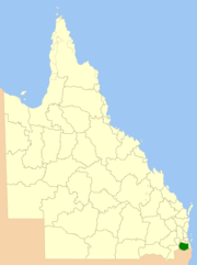
Location within Queensland
|
|||||||||||||
| Population | 39,757 (2015 Est.) | ||||||||||||
| • Density | 9.3414/km2 (24.1941/sq mi) | ||||||||||||
| Established | 2008 | ||||||||||||
| Area | 4,256 km2 (1,643.3 sq mi) | ||||||||||||
| Mayor | Greg Christensen | ||||||||||||
| Council seat | Beaudesert | ||||||||||||
| Region | West Moreton | ||||||||||||
| State electorate(s) | Beaudesert | ||||||||||||
| Federal Division(s) | Wright | ||||||||||||
 |
|||||||||||||
| Website | Scenic Rim Region | ||||||||||||
|
|||||||||||||
The Scenic Rim Region is a local government area in West Moreton region of South East Queensland, Australia. Established in 2008, it was preceded by several previous local government areas with histories extending back to the early 1900s and beyond. The main town of the region is Beaudesert.
It has an estimated operating budget of A$33 million.
Prior to 2008, the new Scenic Rim Region was an entire area of three previous and distinct local government areas:
In July 2007, the Local Government Reform Commission released its report and recommended that the areas amalgamate. It identified a rural community of interest as well as ecotourism potential from the Scenic Rim, a group of mountain ranges forming part of the Great Dividing Range, and recommended the transfer of the entire urban growth corridor previously within Beaudesert to Logan City. Along with Lockyer Valley and Somerset, it was expected to provide a rural hinterland for urban South East Queensland. The arrangement was Boonah's second preference (its first was simply absorbing the rural areas of Ipswich) while Beaudesert opposed splitting or amalgamation.
The legislation passed to effect the merger on 10 August 2007. A Local Transition Committee made up of staff and councillors of the dissolving entities was formed to manage the process. On 15 March 2008, the Shires formally ceased to exist, and elections were held on the same day to elect councillors and a mayor to the Regional Council.
The region is mostly rural, with Beaudesert and Boonah the main towns. It lies within the catchment areas of the Bremer River, the Logan River/Albert River and the Coomera River/Nerang River. The centre of the area is dominated by the Teviot Range and broad sweep of mountainous terrain forming a southern boundary with the local government area on Queensland's southern border with New South Wales. Many high altitude area are covered by forests and protected in national parks (including World Heritage listings) at Tamborine Mountain, McPherson Range, Main Range National Park, Mount Barney National Park and landforms including Cunninghams Gap and Fassifern Valley. South East Queensland's highest mountain is Mount Barney, reaching 1,356 metres above sea level. Wyaralong Dam is the region's newest reservoir.
...
Wikipedia
