Mount Lindesay Highway
|
Mount Lindesay Highway Mount Lindesay Road - Beaudesert Road Queensland |
|
|---|---|
 |
|
| Mount Lindesay Highway (green and black) | |
| Type | Highway |
| Length | 116 km (72 mi) |
| Route number(s) |
|
| North end |
Moorooka, Brisbane |
|
|
| South end |
|
| Major settlements | Jimboomba, Beaudesert, Rathdowney |
|
Highways in Australia National Highway • Freeways in Australia Highways in Queensland |
|
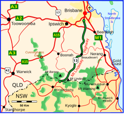
The Mount Lindesay Highway is an Australian national highway located in Queensland, also known as National Route 13. The highway runs southwest from Brisbane, where it leaves Ipswich Road in the suburb of Moorooka (as Beaudesert Road to the Logan Motorway), to the Queensland – New South Wales border and is approximately 116 kilometres (72 mi) in length. For most of its length it is roughly aligned with the Sydney–Brisbane rail corridor. At its southern end these transport routes take different passes over the Scenic Rim into the Northern Rivers region.
Until 1954, the route was part of the New England Highway between Sydney and Brisbane. However, the opening of the road from Tenterfield to Wallangarra created a better road for the New England Highway and this route was renamed the Mount Lindesay Highway. Until 1977, the Mount Lindesay Highway as a named road extended beyond the Queensland – New South Wales border to Tenterfield but the New South Wales section of the road, which still includes some unpaved portions, was decommissioned as a highway by the New South Wales Government due to very low traffic volumes. Approximately 8 kilometres (5.0 mi) south of the Queensland – New South Wales border the decommissioned part of the Mount Lindesay Highway intersects the northern end of the Summerland Way, known as New South Wales route B91, which runs south to Casino and then on to Grafton.
...
Wikipedia
