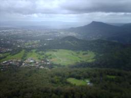
Mount Kembla
|
Mount Kembla Wollongong, New South Wales |
|||||||||||||
|---|---|---|---|---|---|---|---|---|---|---|---|---|---|

The suburb of Mount Kembla viewed from Mount Keira
|
|||||||||||||
| Coordinates | 34°25′43″S 150°49′28″E / 34.42861°S 150.82444°E | ||||||||||||
| Population | 1,028 (2011 census) | ||||||||||||
| • Density | 643/km2 (1,660/sq mi) | ||||||||||||
| Postcode(s) | 2526 | ||||||||||||
| Elevation | 534 m (1,752 ft) | ||||||||||||
| Area | 1.6 km2 (0.6 sq mi) | ||||||||||||
| LGA(s) | City of Wollongong | ||||||||||||
| State electorate(s) | Wollongong | ||||||||||||
| Federal Division(s) | Cunningham | ||||||||||||
|
|||||||||||||
| Mount Kembla | |
|---|---|
| Hat Hill | |

View of Mount Kembla from Mount Nebo
|
|
| Highest point | |
| Elevation | 534 m (1,752 ft) |
| Coordinates | 34°26′30″S 150°48′30″E / 34.44167°S 150.80833°ECoordinates: 34°26′30″S 150°48′30″E / 34.44167°S 150.80833°E |
| Geography | |
|
Location in New South Wales
|
|
| Location | Illawarra region, New South Wales, Australia |
Mount Kembla /ˈkɛmblə/ is a suburb and a mountain in the Illawarra region of New South Wales, Australia.
The suburb, a semi-rural township of Wollongong, gets its name from the mountain, located on the Illawarra escarpment, is derived from an Aboriginal word, kembla, meaning "plenty of game". The satellite localities of Kembla Heights, Windy Gully, Cordeaux Valley and Kembla Village are comprised within the suburb of Mount Kembla that at the 2011 census had a population of 1,028.
The summit of Mount Kembla has an elevation of 534 metres (1,752 ft) above sea level.
The area surrounding Mount Kembla is a coal mining area, notable for the Mount Kembla Mine disaster of 1902 in which 96 people lost their lives.
The suburb of Mount Kembla and its associated "main" village includes a local primary school, church and graveyard, several hundred houses and the Mount Kembla Hotel, which was built in 1896. The general store/post office closed in 2010, making it the first time in 145 years the village has been without one. The village also has a heritage centre showcasing local history, emphasizing the mining disaster. An annual Heritage Festival and 96 Candles Ceremony, commemorating the victims of the mine disaster, have been performed consistently every year since the disaster. The village is accessible from Wollongong, via Cordeaux Road, named after early settlers; and from Mount Keira via Harry Graham Drive. The small village of Kembla Heights is to the northwest, reached by Harry Graham Drive.
...
Wikipedia

