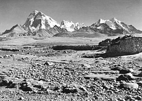
Mount Jomolhari
| Jomolhari | |
|---|---|
| Chomo Lhari | |

Jomolhari seen from the southwest
Picture taken in Phari, Tibet, in 1938 |
|
| Highest point | |
| Elevation | 7,326 m (24,035 ft) Ranked 79th |
| Prominence | 2,077 m (6,814 ft) |
| Listing | Ultra |
| Coordinates | 27°49′27″N 89°16′12″E / 27.82417°N 89.27000°ECoordinates: 27°49′27″N 89°16′12″E / 27.82417°N 89.27000°E |
| Naming | |
| Translation | Mountain of the Goddess (Tibetan) |
| Geography | |
| Location |
Thimphu, Bhutan Tibet, China |
| Parent range | Himalaya |
| Climbing | |
| First ascent | May 1937 |
Jomolhari or Chomolhari (Tibetan: ཇོ་མོ་ལྷ་རི, Wylie: jo mo lha ri; Chinese: 绰莫拉日峰; pinyin: Chuòmòlārì Fēng) sometimes known as "the bride of Kangchenjunga”, is a mountain in the Himalayas, straddling the border between Yadong County of Tibet, China and the Thimphu district of Bhutan. The north face rises over 2,700 metres (8,900 ft) above the barren plains. The mountain is the source of the Paro Chu (Paro river) which flows from the south side and the Amo Chu which flows from the north side.
The mountain is sacred to Tibetan Buddhists who believe it is the abode of one of the Five Tsheringma Sisters;(jo mo tshe ring mched lnga) — female protector goddesses (Jomo) of Tibet and Bhutan, who were bound under oath by Padmasambhava to protect the land, the Buddhist faith and the local people.
On the Bhutanese side is a Jomolhari Temple, toward the south side of the mountain about a half-day's journey from the army outpost between Thangthangkha and Jangothang at an altitude of 4150 meters. Religious practitioners and pilgrims visiting Mt. Jomolhari stay at this temple. There are several other sacred sites near Jomolhari Temple, including meditation caves of Milarepa and Gyalwa Lorepa. Within an hour's walk up from the temple at an altitude of c. 4450 meters is Tseringma Lhatso, the "spirit lake" of Tsheringma.
...
Wikipedia

