Mount Ilgaz National Park
| Mount Ilgaz National Park | |
|---|---|
| Ilgaz Dağı Milli Parkı | |
|
IUCN category II (national park)
|
|

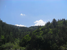
A view from Mount Ilgaz
|
|
| Location | Kastamonu Province-Çankırı Province, Turkey |
| Nearest city | Kastamonu |
| Coordinates | 41°04′24″N 33°48′25″E / 41.07333°N 33.80694°ECoordinates: 41°04′24″N 33°48′25″E / 41.07333°N 33.80694°E |
| Area | 742.38 ha (1,834.5 acres) |
| Established | June 2, 1976 |
| Governing body | Directorate-General of Nature Protection and National Parks Ministry of Environment and Forest |
The Mount Ilgaz National Park (Turkish: Ilgaz Dağı Milli Parkı) is a protected area established on June 2, 1976 and located on the Ilgaz Mountains at the borderline between Kastamonu Province and Çankırı Province in the western Black Sea Region of Turkey. Natural resources and its potential for recreational activities are the main values of the national park, which stretches over an area of 742.38 ha (1,834.5 acres).
The terrain structure of the Mount Ilgaz region, which is on the transient zone from Central Anatolia to North Anatolia, is characterized in general by serpentinite, schist and volcanic rock. There are also interesting examples in the region regarding mountain formation. Turkey's longest and most active geological fracture, the North Anatolian Fault, runs through the southern foot of Mount Ilgaz. The intire region features valleys, slopes and peaks of different characters. Additionally, it has geomorphological structure with a high-level landscape speciality.
The national park is on the Ilgaz Mountains, a mountain range in the western Black Sea Region. The mountains are bordered in the north by Gökırmak River and in the south by Devrez Creek, forming the hydrographic boundary between the two river basins. The Gökırmak River originates in the northern slopes of the Ilgaz Mountains, and flows in the west-east direction joining Kızılırmak River as one of its main tributaries. Devrez Creek follows the North Anatolian Fault joining also Kızılırmak in the east.
...
Wikipedia

