Mount Hood Village, Oregon
| Mount Hood Village, Oregon | |
|---|---|
| Census-designated place | |
 |
|
| Coordinates: 45°21′14″N 121°58′33″W / 45.35389°N 121.97583°WCoordinates: 45°21′14″N 121°58′33″W / 45.35389°N 121.97583°W | |
| Country | United States |
| State | Oregon |
| County | Clackamas |
| Area | |
| • Total | 26.1 sq mi (67.7 km2) |
| • Land | 26.1 sq mi (67.7 km2) |
| • Water | 0.0 sq mi (0.0 km2) |
| Elevation | 1,247 ft (380 m) |
| Population (2010) | |
| • Total | 4,864 |
| • Density | 186/sq mi (71.8/km2) |
| Time zone | Pacific (PST) (UTC-8) |
| • Summer (DST) | PDT (UTC-7) |
| ZIP code | 97067 |
| Area code(s) | 503 and 971 |
| FIPS code | 41-50235 |
| GNIS feature ID | 1867474 |
| Website | [1] |
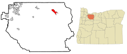
Mount Hood Village is the name of a census-designated place (CDP) within the Mount Hood Corridor in Clackamas County, Oregon, United States. As of the 2010 census, the CDP had a population of 4,864.The Villages at Mount Hood is the name of the combined government of several of the communities encompassed by the CDP and is a separate entity.
The Villages at Mount Hood is the common of the unincorporated communities of the Mount Hood Corridor, and includes Brightwood, Welches, Wemme, Zigzag and Rhododendron. Residents approved its formation in May 2006.
The Villages at Mount Hood was the first established village under Clackamas County's "Complete Communities" ordinance, which allows unincorporated communities to form quasi-governments that allow them to have more direct control regarding the issues and activities that affect them.
According to the village's official website, the communities united to form the village because the Oregon Department of Transportation required that the towns create a "governmental agency" in order to continue getting grants for the growing Mount Hood Express bus system. The "Complete Communities" ordinance makes villages and hamlets official agencies of the county.
The Villages at Mount Hood have thus far approved (and now oversee) the following activities:
The CDP includes most of Brightwood, Wemme, Welches, Zigzag, and Rhododendron. Most of the area is immediately north or south of U.S. Route 26, though a spur south into parts of Welches and a spur north along East Lolo Pass Road is also included.
...
Wikipedia
