Mount Hakkoda
| Hakkōda Mountains | |
|---|---|
| 八甲田山系 Hakkōda-sankei | |

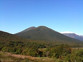
The Hakkōda Mountains viewed from southeast.
|
|
| Highest point | |
| Peak | Mount Ō |
| Elevation | 1,584 m (5,197 ft) |
| Coordinates | 40°39′22″N 140°52′51″E / 40.65611°N 140.88083°ECoordinates: 40°39′22″N 140°52′51″E / 40.65611°N 140.88083°E |
| Geography | |
| Country | Japan |
| State | Aomori Prefecture |
| Region | Tōhoku |
| Parent range | Ōu Mountains |
| Biome | Alpine climate |
| Geology | |
| Orogeny | Island arc |
| Type of rock | Volcanic |
The Hakkōda Mountains (八甲田山系 Hakkōda-sankei?) is a volcanic mountain range that lies to the south of Aomori city in Aomori Prefecture, Japan. The range consists of more than a dozen stratovolcanoes and lava domes arranged into two volcanic groups. The Northern Hakkōda Volcanic Group emerges from the rim of an 8-km wide caldera that dates back to the . The Southern Hakkōda Volcanic Group predates the caldera.
The highest peak in the range is Mount Ōdake, which can be climbed from Sukayu Onsen in about four hours. Heavy snowfall makes Hakkoda a prime destination for backcountry and mountain skiers, and there are two mountain huts for overnight trips. The lower slopes of the mountains are forested interspersed with moorland. Above 1300 meters, the Alpine climate zone starts.
The Hakkōda Mountains, along with Lake Towada and the Oirase Valley make up the Towada-Hachimantai National Park.
The volcanic peaks are made of non-alkali mafic rock; mostly andesite, dacite, and basalt. Although both groups of mountains formed in the Pleistocene, the southern group is older than the northern group. The southern group is made from rock that is 700,000 to 1,700,000 years old, while the northern group is made from rock that is 13,000 to 700,000 years old.
...
Wikipedia
