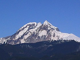
Mount Garibaldi
| Mount Garibaldi | |
|---|---|

Mount Garibaldi as seen from Squamish
|
|
| Highest point | |
| Elevation | 2,678 m (8,786 ft) |
| Prominence | 855 m (2,805 ft) (estimated) |
| Listing | List of volcanoes in Canada List of Cascade volcanoes |
| Coordinates | 49°51′02″N 123°00′17″W / 49.85056°N 123.00472°WCoordinates: 49°51′02″N 123°00′17″W / 49.85056°N 123.00472°W |
| Geography | |
| Parent range | Garibaldi Ranges |
| Topo map | NTS 92G/14 |
| Geology | |
| Age of rock | |
| Mountain type | Stratovolcano |
| Volcanic arc/belt | Canadian Cascade Arc Garibaldi Volcanic Belt |
| Last eruption | 8060 BCE ± 500 years |
| Climbing | |
| First ascent | 1907 A. Dalton; W. Dalton; W. Dalton; A. King; T. Pattison; J.J. Trorey; G. Warren |
| Easiest route | Glacier travel, snow climb |
Mount Garibaldi is a potentially activestratovolcano in the Sea to Sky Country of British Columbia, 80 km (50 mi) north of Vancouver, British Columbia, Canada. Located in the southernmost Coast Mountains, it is one of the most recognized peaks in the South Coast region, as well as British Columbia's best known volcano. It lies within the Garibaldi Ranges of the Pacific Ranges.
This heavily eroded dome complex occupies the southwest corner of Garibaldi Provincial Park overlooking the town of Squamish. It is the only major age volcano in North America known to have formed upon a glacier. Although part of the Garibaldi Volcanic Belt within the Cascade Volcanic Arc, it is not considered part of the Cascade Range.
To Squamish people, the local indigenous people of this territory, the mountain is called Nch'kay. In their language it means "Dirty Place" or "Grimy One". This name of the mountain refers to the muddy water in the Cheekye River. This mountain, like others located in the area, is considered sacred for it plays an important part in their history. In their oral history, they passed down a story of the flood covering the land. During this time, only two mountains peaked over the water, and this mountain was one of them. It was here that the remaining survivors of the flood latched their canoes to the peak and waited for the waters to subside. The mountain also serves as weather indicator to the people, as when clouds cover the face of the mountain, it signals the coming of rain or snow. Cultural ceremonial use, hunting, trapping and plant gathering occur around the Mount Garibaldi area, but the most important resource was a lithic material called obsidian. Obsidian is a black volcanic glass that was used to make knives, chisels, adzes, and other sharp tools in pre-contact times. This material appears in sites dated to 10,000 years ago up to protohistoric time periods. The source for this material is found in upper parts of the mountain area in higher elevations that surround the mountain range.
...
Wikipedia

