Mount Dōgo
| Mount Dōgo | |
|---|---|
| 道後山 | |

Mount Dōgo
|
|
| Highest point | |
| Elevation | 1,268 m (4,160 ft) |
| Coordinates | 35°04′12″N 133°14′09″E / 35.07000°N 133.23583°ECoordinates: 35°04′12″N 133°14′09″E / 35.07000°N 133.23583°E |
| Geography | |
|
|
|
| Parent range | Chūgoku Mountains |
| Climbing | |
| Easiest route | Hiking |
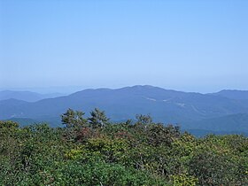
Mount Dōgo (道後山 Dōgo-yama), is a volcanic mountain located on the border of Nichinan, Tottori Prefecture and Shōbara, Hiroshima Prefecture. The mountain has an elevation of 1,268 m (4,160 ft). The name of Mount Dōgo in Japanese is formed from two kanji. The first, , means "road" and the second, , in this context means "behind" or "to the rear". Due to its scenery mountain is known as the "Queen of the Chūgoku Mountains."
Mount Dōgo is part of Hiba-Dogo-Taishaku Quasi-National Park, and is the second largest mountain in the park after Mount Hiba. Mount Dōgo offers a clear view of Mount Hiba to the west and Daisen and the Japan Sea to the north. On clear days the Shimane Peninsula is also visible from the mountain. The Nariwa River, a prominent tributary of the Takahashi River, originates at Mount Dōgo. The border of Tottori Prefecture and Hiroshima Prefecture is marked by a low 1,268 m (4,160 ft) long stone wall.
High-elevation flatlands, particularly the broad area known as Noro on the Hiroshima Prefecture side of Mount Dōgo. The plain is used as pastureland for dairy farms and cattle.Wagyu cattle are farmed in this area.
Mount Dōgo features outstanding examples of numerous trees, including the:
Higher elevations of Mount Dōgo feature alpine plants. Warabi (Pteridium aquilinum), a bracken fern used in Japanese cuisine, are collected in early spring around Mount Dōgo.
Mount Dōgo is known for its various species of flowers.
...
Wikipedia

