Mount Chocorua
| Mount Chocorua | |
|---|---|

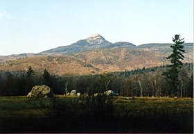
Mount Chocorua from Fowler's Mill Road
|
|
| Highest point | |
| Elevation | 3480+ ft (1061+ m) |
| Prominence | 1,240 ft (380 m) |
| Coordinates | 43°57′15″N 71°16′24″W / 43.95417°N 71.27333°WCoordinates: 43°57′15″N 71°16′24″W / 43.95417°N 71.27333°W |
| Geography | |
| Location | Albany, New Hampshire, U.S. |
| Parent range | Sandwich Range, White Mountains |
| Topo map | USGS Mount Chocorua |
| Climbing | |
| Easiest route | Piper Trail Champney Falls Trail Liberty Trail |
Mount Chocorua (IPA: /ʃʌˈkɔʊˌɹwə/) is a summit in the White Mountains of New Hampshire. At an elevation of 3,490 feet (1,064 m) it is the easternmost peak of the Sandwich Range. Although the range is not outstanding for its elevation, it is very rugged and has excellent views of the surrounding lakes, mountains, and forests. Mount Chocorua's bare summit can be seen from almost every direction and can be identified from many points throughout central New Hampshire and western Maine.
Mount Chocorua is located in the town of Albany and is the easternmost peak of the Sandwich Range in New Hampshire's White Mountain National Forest. The Sandwich Range is located north of the Lakes Region and south of the Kancamagus Highway. The range extends about 30 miles (50 km) east-west from Conway on the Saco River to Campton on the Pemigewasset. Chocorua's summit is a picturesque rocky cone, and the mountain is purported to be one of the most photographed in the world (AMC Guide, page 310). One of the most photographed sites is from Chocorua Lake, which often casts a perfect reflection of the mountain top. This lakeside view of Mount Chocorua was chosen to represent the White Mountain National Forest on a quarter issued by the U.S. Mint in 2013 as part of its America the Beautiful coin series.
Mount Chocorua is a popular destination for hikers. Although it is under 3,500 feet (1,100 m) in elevation, its bare and rocky summit commands excellent views in all directions. Since most trails begin at much lower elevations, a hike to the summit is a strenuous exercise. There are many trails up the mountain, and they can be quite crowded during the summer months. Especially popular are the Piper Trail (4.2 miles (6.8 km) each way from the east), the Champney Falls Trail (from the north), and the Liberty Trail (from the southwest).
...
Wikipedia

