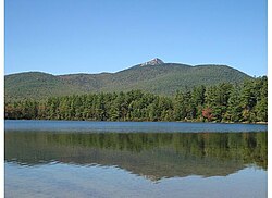
Chocorua Lake
| Chocorua Lake | |
|---|---|

The lake with the summit of Mount Chocorua casting a reflection
|
|
| Location | Carroll County, New Hampshire |
| Coordinates | 43°54′02″N 71°14′14″W / 43.90056°N 71.23722°WCoordinates: 43°54′02″N 71°14′14″W / 43.90056°N 71.23722°W |
| Primary inflows | Chocorua River, Stratton Brook |
| Primary outflows | Chocorua River |
| Catchment area | 13.2 sq mi (34 km2) |
| Basin countries | United States |
| Max. length | 1.1 mi (1.8 km) |
| Max. width | 3,500 ft (1,100 m) |
| Surface area | 222 acres (90 ha) |
| Average depth | 12 ft (3.7 m) |
| Max. depth | 27 ft (8.2 m) |
| Surface elevation | 574 ft (175 m) |
| Settlements | Chocorua (town of Tamworth) |
| References | |
Chocorua Lake is a picturesque lake in northeast New Hampshire with commanding views of the summit of Mount Chocorua. It is approximately 1.1 miles (1.8 km) long (north-south) with a maximum width of 3,500 ft (1.1 km) (east-west), covering 222 acres (890,000 m²), and a maximum depth of 27 feet (8.2 meters).
The lake is most noted for its calm, serene setting. There is little to no development surrounding it, and its stunning views of the bald summit of Mount Chocorua are unblemished by radio antennas.
Chocorua Lake, also commonly called Lake Chocorua, is located in east-central New Hampshire in the town of Tamworth, New Hampshire. It is located in the Ossipee Lake watershed south of the White Mountains region. The watershed is 13.2 square miles (34 km2) of mostly protected forest under the management of the United States Forest Service. The main inflow into the lake is the Chocorua River from the north, which drains the south side of Mount Chocorua. Stratton Brook flows into the west side of the lake. The lake's outflow is to the south, through Little Chocorua Lake, then through a dam outfall into the Chocorua River. (Though the lake has a dammed outlet, it is a natural lake, not a reservoir, with the dam serving to maintain the water level of the lake at precisely 574 feet above sea level.) The water from the Chocorua Lake outfall and the Chocorua River eventually reaches the Bearcamp River and enters Ossipee Lake, then the Saco River and finally the Atlantic Ocean on the coast of Maine.
...
Wikipedia
