Mount Aso
| Mount Aso | |
|---|---|
| 阿蘇山 | |

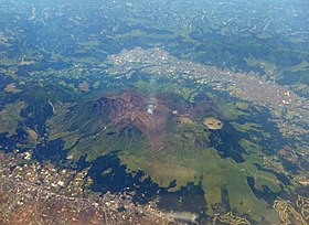
Central cone group of Aso caldera
|
|
| Highest point | |
| Elevation | 1,592 m (5,223 ft) |
| Coordinates | 32°53′04″N 131°06′14″E / 32.88444°N 131.10389°ECoordinates: 32°53′04″N 131°06′14″E / 32.88444°N 131.10389°E |
| Geography | |
|
Kyushu, Japan
|
|
| Geology | |
| Mountain type | Caldera complex |
| Last eruption | October 2016 - Present |
Mount Aso (阿蘇山 Aso-san?) is the largest active volcano in Japan, and is among the largest in the world. It stands in Aso Kujū National Park in Kumamoto Prefecture, on the island of Kyushu. Its peak is 1,592 metres (5,223 ft) above sea level. Mt. Aso has a fairly large caldera (25 kilometres (16 miles) north-south and 18 km (11 mi) east-west) with a circumference of around 120 km (75 mi), although sources vary on the exact distance.
The central cone group of Aso consists of five peaks: Mt. Neko, Mt. Taka, Mt. Naka (also called Nakadake or Naka-Dake), Mt. Eboshi, and Mt. Kishima. The highest point is the summit of Mt. Taka, at 1592 m above sea level. The crater of Mt. Naka, the west side of which is accessible by road, contains an active volcano which continuously emits smoke and has occasional eruptions. Only the northernmost crater (the first crater) has been active for the last 70 years—1974, 1979, 1984–1985, 1989–1991, 2009, 2011, 2015 and 2016.
The present Aso caldera formed as a result of four huge caldera eruptions occurring over a range of 90,000–300,000 years ago. The caldera, one of the largest in the world, contains the city of Aso as well as Aso Takamori-cho and South Aso-mura. The somma enclosing the caldera extends about 18 km east to west and about 25 km north to south. Viewpoints from the somma overlooking the caldera are perched upon lava formed before the volcanic activity which created the present caldera. Ejecta from the huge caldera eruption 90,800 years ago covers more than 600 km3 and roughly equals the volume of Mount Fuji; it is presumed that the pyroclastic flow plateau covered half of Kyushu.
...
Wikipedia

