Minamiaso, Kumamoto
|
Minamiaso 南阿蘇村 |
|
|---|---|
| Village | |

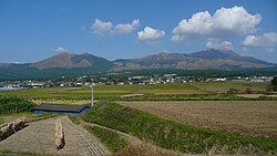
View of Mount Aso from Minami-Aso
|
|
 Location of Minamiaso in Kumamoto Prefecture |
|
| Location in Japan | |
| Coordinates: 32°49′N 131°2′E / 32.817°N 131.033°ECoordinates: 32°49′N 131°2′E / 32.817°N 131.033°E | |
| Country | Japan |
| Region | Kyushu |
| Prefecture | Kumamoto Prefecture |
| District | Aso |
| Government | |
| • Mayor | Toshiya Nagano (since February 2005) |
| Area | |
| • Total | 137.30 km2 (53.01 sq mi) |
| Population (December 31, 2009) | |
| • Total | 12,015 |
| • Density | 88/km2 (230/sq mi) |
| Symbols | |
| • Tree | Chamaecyparis obtusa |
| • Flower | Pieris japonica |
| • Bird | Emberiza cioides |
| Time zone | Japan Standard Time (UTC+9) |
| City hall address | 145-3 Kain, Minamiaso-mura, Aso-gun, Kumamoto-ken 869-1411 |
| Website | www |
Minamiaso (南阿蘇村 Minamiaso-mura?, literally "South Aso") is a village in Aso District, Kumamoto Prefecture, Japan.
It was formed on February 13, 2005 from the merger of the villages of Chōyō, Hakusui and Kugino. Neighbouring towns are Takamori, Ozu, and Nishihara.
As of December 31, 2009, the village has an estimated population of 12,015 (5,776 male, 6,239 female) and a population density of 91.2 persons per km². The total area is 137.30 km².
Minamiaso is situated within Aso Caldera, one of the largest volcanic calderas in the world. For more information, refer to the entry on Mt. Aso.
Minamiaso was once three separate villages: Chōyō, Hakusui and Kugino. In 2005, it was decided that these villages would merge along with neighboring area Tateno to become Minamiaso village, which would stretch between Ozu and Takamori.
Due to declining birth rate, aging population and the opportunity to share administrative resources, discussions between the three villages (Chōyō, Hakusui and Kugino) began on April 1, 2003. The merger was complete on February 13, 2005.
...
Wikipedia

