Mount Aqraa
| Jebel Aqra | |
|---|---|
| جبل الأقرع | |

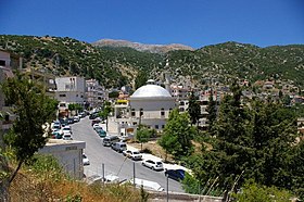
Jebel Aqra overlooking the town of Kesab
|
|
| Highest point | |
| Elevation | 1,709 m (5,607 ft) |
| Coordinates | 35°57′9″N 35°58′9.5″E / 35.95250°N 35.969306°ECoordinates: 35°57′9″N 35°58′9.5″E / 35.95250°N 35.969306°E |
| Geography | |
| Location |
Latakia Governorate, Kesab, Syria Hatay Province, Turkey |
Jebel Aqra, properly Jebel al-ʾAqraʿ (Arabic: جبل الأقرع, [ˈd͡ʒæbæl al ˈʔaqraʕ]; Turkish: Cebel-i Akra), is a limestone mountain located on the Syrian–Turkish border near the mouth of the Orontes River on the Mediterranean Sea. Its Turkish side is also known as Mount Kel (Kel Dağı). Rising from a narrow coastal plain, Jebel Aqra is a mariners' landmark which gathers thunderstorms.
The cult site is still represented by a huge mound of ashes and debris, 180 feet (55 m) wide and 26 feet (7.9 m) deep, of which only the first 6 feet (1.8 m) have been excavated. The researchers only reached as far as the Hellenistic strata before the site was closed, as it lies in a Turkish military zone on its border with Syria.
Jebel Aqra has a long history as a sacred mountain.
The Hurrians called it Mount Hazzi and considered it the home of their storm god Teshub. The Hittites continued his worship, celebrating Teshub's victory over the sea in the Song of Kumarbi found in their capital Hattusa. They also celebrated the mountain in its own right, naming it as a divine guarantor on their treaties and observing rites in its honor.
...
Wikipedia

