Mosquito Coast
| Mosquito Coast | ||||||||||
| English and British protectorate (1638–1787, 1844–1860) Spanish Colony (1787–1800, de jure 1819) Autonomous territory of Nicaragua (1860–1894) |
||||||||||
|
||||||||||
|
||||||||||
| Capital | Sandy Bay Bluefields (after 1787) |
|||||||||
| Languages |
Miskito English Spanish |
|||||||||
| Government | Monarchy | |||||||||
| King | ||||||||||
| • | c.1650–1687 | Oldman (first known) | ||||||||
| • | 1842–1860 | George Augustus Frederic II (last) | ||||||||
| Hereditary Chief | ||||||||||
| • | 1860–1865 | George Augustus Frederic II (first) | ||||||||
| • | 1890–1894 | Robert Henry Clarence (last) | ||||||||
| History | ||||||||||
| • | Established | Early 17th century | ||||||||
| • | Disestablished | 1894 | ||||||||
|
||||||||||
| Today part of |
|
|||||||||
| Mosquito Kingdom | ||||||||||||
| Protectorate of England (1638–1707) Protectorate of Great Britain (1707–1787) |
||||||||||||
|
||||||||||||
|
Anthem God Save the King (1745–1787) |
||||||||||||
| Capital | Sandy Bay (King's residence) |
|||||||||||
| Languages |
Miskito English |
|||||||||||
| Government | Monarchy | |||||||||||
| Monarch | ||||||||||||
| • | c.1650–1687 |
Oldman (first known) |
||||||||||
| • | 1776–1801 |
George II Frederic (last) |
||||||||||
| Superintendent of the Shore | ||||||||||||
| • | 1749–1759 | Robert Hodgson, Sr. (first) | ||||||||||
| • | 1775–1787 | James Lawrie (last) | ||||||||||
| History | ||||||||||||
| • | Arrival of the Providence Island Company | 1630 | ||||||||||
| • | British ally | 1638 | ||||||||||
| • | British protectorate | 1740 | ||||||||||
| • | Convention of London | 1786 | ||||||||||
| • | British evacuation | 1787 | ||||||||||
| Currency | Pound sterling | |||||||||||
|
||||||||||||
| Mosquito Kingdom | ||||||||||||||
| Protectorate of the United Kingdom | ||||||||||||||
|
||||||||||||||
|
Anthem God Save the Queen |
||||||||||||||
| Capital | Bluefields | |||||||||||||
| Languages |
English Miskito |
|||||||||||||
| Government | Monarchy | |||||||||||||
| King | ||||||||||||||
| • | 1842–1860 | George Augustus Frederic II | ||||||||||||
| Consul-General Consul (after 1851) |
||||||||||||||
| • | 1844–1848 | Patrick Walker (first) | ||||||||||||
| • | 1849–1860 | James Green (last) | ||||||||||||
| History | ||||||||||||||
| • | Protectorate declared | 1844 | ||||||||||||
| • | Annexation of San Juan del Norte | 1848 | ||||||||||||
| • | Bombardment of San Juan del Norte | 1854 | ||||||||||||
| • | Treaty of Managua | January 28, 1860 | ||||||||||||
| Currency | Pound Sterling | |||||||||||||
|
||||||||||||||
| Mosquito Reserve | ||||||||||
| Reserva Mosquitia | ||||||||||
| Autonomous territory of Nicaragua | ||||||||||
|
||||||||||
|
||||||||||
|
Anthem Hermosa Soberana |
||||||||||
| Capital | Bluefields | |||||||||
| Languages |
Spanish Miskito |
|||||||||
| Government | Monarchy | |||||||||
| Hereditary Chief | ||||||||||
| • | 1860-1865 | George Augustus Frederic II (first) | ||||||||
| • | 1890-1894 | Robert Henry Clarence (last) | ||||||||
| History | ||||||||||
| • | Treaty of Managua | January 28, 1860 | ||||||||
| • | Annexation to Nicaragua | 1894 | ||||||||
| Currency |
Nicaraguan peso Pound sterling |
|||||||||
|
||||||||||
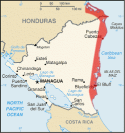
The Mosquito Coast, also known as the Miskito Coast, historically comprised an area along the eastern coast of present-day Nicaragua and Honduras. It formed part of the Western Caribbean Zone. It was named after the local Miskito Amerindians and was long dominated by British interests. The Mosquito Coast was incorporated into Nicaragua in 1894; however, in 1960, the northern part was granted to Honduras by the International Court of Justice.
The Mosquito Coast was generally defined as the domain of the Mosquito or Miskito Kingdom and expanded or contracted with that domain. During the nineteenth century, the question of the kingdom's borders was a serious issue of international diplomacy between Britain, the United States, Nicaragua, and Honduras. Conflicting claims regarding both the kingdom's extent and arguable nonexistence were pursued in diplomatic exchanges. The British and Miskito definition applied to the whole eastern seaboard of Nicaragua and even to La Mosquitia in Honduras: i.e., the coast region as far west as the Río Negro or Tinto. The Mosquito Coast in the later part of the century came to be considered as the narrow strip of territory, fronting the Caribbean Sea and extending from about 11°45’ to 14°10’ N. It stretched inland for an average distance of 60 kilometers (40 mi), and measured about 400 kilometers (225 mi) from north to south. In the north, its boundary skirted the Wawa River; in the west, it corresponded with the eastern limit of the Nicaraguan highlands; in the south, it followed the Río Rama. The chief modern towns are Bluefields, the largest town and capital of Nicaragua's South Caribbean Coast Autonomous Region; Magdala on Pearl Cay; Prinzapolka on the river of that name; Wounta near the mouth of the Kukalaya; and Karata near the mouth of the Coco River.
...
Wikipedia


