Morton Bagot
| Morton Bagot | |
|---|---|
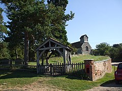
 Holy Trinity Church and Lych gate |
|
| Morton Bagot shown within Warwickshire | |
| Population | 153 (2001 Census) |
| OS grid reference | SP11366460 |
| District | |
| Shire county | |
| Region | |
| Country | England |
| Sovereign state | United Kingdom |
| Post town | Studley |
| Postcode district | B80 |
| Dialling code | 01527 |
| Police | Warwickshire |
| Fire | Warwickshire |
| Ambulance | West Midlands |
| EU Parliament | West Midlands |
| UK Parliament | |
Morton Bagot is a small village in the Stratford-on-Avon district of Warwickshire, England. The population from the 2011 Census is included within Redditch(Worcs). It lies about 1.5 miles (2 km) east of the Birmingham-Alcester road, the modern A435 and Roman Ryknild Street, 6.5 miles (10 km) north of Alcester, 9.5 miles (15 km) from Stratford upon Avon and 12 miles from Warwick, across the valley of a small brook, flowing south-east to join the River Arrow. A road from Oldberrow to Spernall runs north and south through the middle of the parish of Morton Bagot, Oldberrow and Spernall, past the church. The name means the settlement of the moor, the Bagot element coming from the name of the lords of the Manor who added their name when they came into possession during the reign of Henry II.
The elevation varies from 200 feet (61 m) to 400 feet (120 m), the highest point being at Bannum's Wood.There is no main village and there has been considerable depopulation here since the 18th century. In 2001 the whole parish had a population of 153.
Morton Bagot is recorded in the Domesday Book as part of the land of Robert De Stafford as follows " in Ferncombe Hundred, Hugh holds 2 hides in Mortone (Bagot). Land for 4 ploughs. In lordship 1; 2 slaves; 5 villagers and 5 smallholders with 2 ploughs. Meadow, 3 furlongs long and 6 perches wide; woodland ½ league long 1 furlong wide. The value was 30s; now 50s. Grimulf held it freely." Dugdale however states that it was part of the possessions of Waga of Wooton Wawen whose lands there were also given to de Stafford. Robert de Stafford was descended from the de Tonei family and had fought stoutly with Duke William against King Harold as a result he had this and other lands bestowed on him. He made Stafford his principal seat, where he had a strong castle and assumed his surname from thence.
...
Wikipedia

