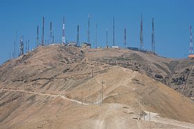
Morro Solar
| Morro Solar | |
|---|---|

Antennas above Chorrillos
|
|
| Highest point | |
| Elevation | 251 m (823 ft) |
| Coordinates | 12°10.92′S 77°01.55′W / 12.18200°S 77.02583°WCoordinates: 12°10.92′S 77°01.55′W / 12.18200°S 77.02583°W |
| Geography | |
| Location | Lima Region, Peru |
Morro Solar (morro in Spanish means: a rounded promontory) is a headland, situated in the district of Chorrillos, to the south of Lima, Peru. Morro Solar is notable for being a site of the Battle of San Juan and Chorrillos between Peruvian and Chilean forces in 1881. Notable landmarks include an astronomical observatory and a monument to an unknown soldier. Its geological formations are rich in silver which is being extracted by several mining companies.
Morro Solar, a cluster of hills, is roughly 251 metres (823 ft) in elevation. It lies near Chorrillos, a southern suburb of Lima, occupying an area of 7.48 square kilometres (2.89 sq mi).Alexander George Findlay described it as "a remarkable cluster of hills, standing on a sandy plain; when seen from the southward it has the appearance of an island in the shape of a quoin, sloping to the westward, and falling very abruptly in-shore; on its sea face, however, it terminates in a steep cliff, with a sandy bay on each side." The sandy shore between Morro Solar and Lurin is known as Conchan Beach. The southwest point of Morro Solar is formed by the Solar Point, located 10 miles (16 km) from San Franscico Island and 10 miles (16 km) to the southwest of Callao. Its sea face terminates in a steep cliff at Codo Point with a sandy bay on each side. The northern side of Morro Solar is the Chorillos Bay which was used in the 1860s for anchoring of ships only in exceptional circumstances as the bottom of the sea consisted of hard sand, clay stones and boulders, which was upseting the stability of the ships. The summit of the hill range provides scenic views of the Bay of Lima, the city of Lima and South Spas.
The Morro Solar is part of the very strange topography of Lima which evolved as a result of geological readjustments. It resulted from high sea winds which shaped the rocky formations in the form of a hollow ring. The geological formation of these hills consists primarily of sedimentary outcrops (shallow marine sedimentary facies) and also of the Andean spurs located North and South of the city. The sedimentary sequence has been mapped with appropriate notes on directions and dips of the strata, faults and dykes and the interpreting geological events. The lithology of rock and other features such as oxidation, fracturing and mineralization have been recorded. The mapping has indicated three terraces with a substantial amount of boulders, at altitudes of 110 m (360 ft), 85 m (279 ft) and near the coast, from the Quaternary Period. Quartzites, shales and sandstones from the Cretaceous and Lower Cretaceous have been reported.
...
Wikipedia

