Mori, Hokkaidō
|
Mori 森町 |
|
|---|---|
| Town | |
| Japanese transcription(s) | |
| • Hepburn romanization | Mori-machi |

Mori Station with Mount Komagatake in the background
|
|
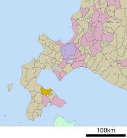
 The location of Mori in Oshima Subprefecture. |
|
| The location of Mori in Japan | |
| Coordinates: 42°6′N 140°35′E / 42.100°N 140.583°ECoordinates: 42°6′N 140°35′E / 42.100°N 140.583°E | |
| Country | Japan |
| Prefecture | Hokkaido |
| Subprefecture | Oshima Subprefecture |
| District | Kayabe |
| Government | |
| • Mayor | Keizō Kajiya |
| Area | |
| • Total | 368.27 km2 (142.19 sq mi) |
| Population (2012-04-01) | |
| • Total | 17,635 |
| • Density | 48/km2 (120/sq mi) |
| Post code | 049-2393 |
| Area code(s) | 01374 |
| Official tree | Chestnut |
| Official flower | Cherry blossom |
| Official bird | Common gull |
| Government Office Address | Banchi 1, Aza Gokōmachi 144, Mori-machi, Kayabe-gun, Hokkaidō 049-2393 |
| Government Office Telephone | 01374-2-2181 |
| Community Identification Number | 01345-5 |
| Website | http://www.town.hokkaido-mori.lg.jp |
Mori (森町 Mori-machi?) is a town located in Kayabe District, Oshima Subprefecture, Hokkaido, Japan.
The total area of the town is 368.27 square kilometres (142.19 sq mi). As of April 2012, the town had a population of 17,635 and a population density of 48 persons per km².
Mount Komagatake, an active volcano, is located to the east of Mori, and much of the town is part of Ōnuma Quasi-National Park. Mori is the home of ikameshi, a squid and rice dish invented in the mid-20th century.
The name of the town originates from the word "Oniushi", meaning "a forested area" in the Ainu language. In the Japanese language the name of the town is written as , meaning forest. The suffix "", denoting town status in Japan, is pronounced as -chō in every municipality of Hokkaido with the exception of Mori, where it is read as -machi.
Mori sits on the eastern coast of the Oshima Peninsula and overlooks Uchiura Bay (30 kilometres (19 mi) in diameter). The bay, also known as Funka Bay, is rich in squid and is the site of scallop aquaculture, both a mainstay of the town economy.
Much of the town of Mori is mountainous or hilly. Hokkaidō Komagatake 1,131 metres (3,711 ft) is an active andesitic stratovolcano on the east of Mori where the town borders the nearby municipalities of Shikabe and Nanae. Major eruptions of Komagatake are recorded as early as 1640, and ash fallout from the volcano is frequent.Mount Gujin (1,113) sits to the west. Volcanic ash from Komagatake covers the town and provides a rich soil for vegetable cultivation.
...
Wikipedia

