Moreland Township, Pennsylvania
| Moreland Township, Pennsylvania |
|
|---|---|
| Township | |

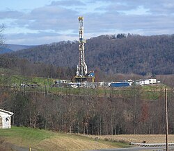
Tower for drilling horizontally into the Marcellus Shale Formation for natural gas, from Pennsylvania Route 118 in eastern Moreland Township
|
|
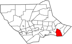
 Map of Lycoming County, Pennsylvania highlighting Moreland Township |
|
 Map of Lycoming County, Pennsylvania |
|
| Coordinates: 41°11′47″N 76°39′28″W / 41.19639°N 76.65778°WCoordinates: 41°11′47″N 76°39′28″W / 41.19639°N 76.65778°W | |
| Country | United States |
| State | Pennsylvania |
| County | Lycoming |
| Settled | 1790 |
| Formed | 1813 |
| Area | |
| • Total | 23.9 sq mi (62.0 km2) |
| • Land | 23.9 sq mi (62.0 km2) |
| • Water | 0.0 sq mi (0.0 km2) |
| Elevation | 1,198 ft (365 m) |
| Population (2000) | |
| • Total | 1,036 |
| • Density | 43.3/sq mi (16.7/km2) |
| Time zone | Eastern Time Zone (North America) (UTC-5) |
| • Summer (DST) | EDT (UTC-4) |
| ZIP code | 17756 |
| Area code(s) | 570 |
| FIPS code | 42-50936 |
| GNIS feature ID | 1216762 |
Moreland Township is a township in Lycoming County, Pennsylvania, United States. The population was 1,036 at the 2000 census. It is part of the Williamsport, Pennsylvania, Metropolitan Statistical Area.
It was divided into three townships in 1822. One part kept the name Moreland and the other two parts were called Penn and Franklin Townships.
The Lairdsville Covered Bridge was added to the National Register of Historic Places in 1980. The Houseknecht Farm was added in 2007.
There are several stories about how Moreland Township was named. One story states that an early pioneer to the West Branch Susquehanna River Valley was climbing up and down the hills and upon reaching the top of a hill exclaimed, "more land!". Another story relates to the "sloppiness" of the earliest land surveys. An acre was not necessarily measured accurately. These particular acres were larger than they were supposed to be. The early settlers liked to say that they got "more land" to the acre here than they could have elsewhere. The most likely reason relates to an arcane definition of moreland, meaning "a hilly country".
A veteran of the American Revolutionary War was the first settler in Moreland Township. Colonel George Smith migrated to Moreland Township from Montgomery County in 1790. He built a gristmill there in 1796. Smith and his wife were the parents of 6 children, 3 boys and 3 girls. The marriage of his daughter, Annie to a Quaker named William Farr causes some controversy in the early history of Moreland Township. William Farr came from a strict Quaker family and they did not look kindly upon his choice of bride. The local Quaker congregation insisted that Farr confess that he had done wrong in marrying outside his faith. Farr refused to do so and insisted that his Baptist wife, Annie, was a good Christian woman. Farr was forced to choose between his Quaker faith and his Baptist wife. He chose his wife and converted to the Baptist faith. Colonel Smith's son, Jonathan, also had a marriage that proved to be interesting. He married Annie Simpson, the sister of John Simpson of Ohio. John Simpson was the grandfather of Ulysses S. Grant who became President of the United States. This family bond meant that many of the residents of Moreland Township in the mid-19th century were second cousins to the man who served as their President.
...
Wikipedia
