Penn Township, Lycoming County, Pennsylvania
| Penn Township, Lycoming County, Pennsylvania |
|
|---|---|
| Township | |

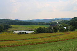
Scenery of Penn Township
|
|
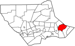
 Map of Lycoming County, Pennsylvania highlighting Penn Township |
|
 Map of Lycoming County, Pennsylvania |
|
| Coordinates: 41°16′48″N 76°38′37″W / 41.28000°N 76.64361°WCoordinates: 41°16′48″N 76°38′37″W / 41.28000°N 76.64361°W | |
| Country | United States |
| State | Pennsylvania |
| County | Lycoming |
| Settled | 1774 |
| Incorporated | 1828 |
| Area | |
| • Total | 26.7 sq mi (69.2 km2) |
| • Land | 26.6 sq mi (68.8 km2) |
| • Water | 0.1 sq mi (0.4 km2) |
| Elevation | 823 ft (251 m) |
| Population (2000) | |
| • Total | 900 |
| • Density | 33.9/sq mi (13.1/km2) |
| Time zone | Eastern (EST) (UTC-5) |
| • Summer (DST) | EDT (UTC-4) |
| FIPS code | 42-58848 |
| GNIS feature ID | 1216767 |
Penn Township is a township in Lycoming County, Pennsylvania, United States. The population was 900 at the 2000 census. It is part of the Williamsport, Pennsylvania Metropolitan Statistical Area.
Penn Township was formed in 1828 when Muncy Township was divided for the fourth time. It is named for Penn Township, Berks County, Pennsylvania in Berks County which is named for William Penn the founder of Pennsylvania. Tobias and Isaac Kepner had migrated to eastern Lycoming County from Berks County and wanted their new home to have the same name as their old home. Much of the history of Penn Township can be found in the history of the Big Runaway and Muncy Township. Lumbering was the dominant industry in Penn Township during the mid-to-late 19th century. A man made lake, Beaver Lake, was built to supply water power for a sawmill. The sawmill has long since disappeared but the lake remains.
Penn Township is bordered by Sullivan County to the northeast, Franklin Township to the east, Moreland Township to the south, Wolf Township and Picture Rocks to the west, and Shrewsbury Township to the northwest.As the crow flies, Lycoming County is about 130 miles (209 km) northwest of Philadelphia and 165 miles (266 km) east-northeast of Pittsburgh.
...
Wikipedia
