Moray Firth
| Moray Firth | |
|---|---|

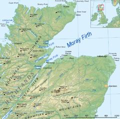
Map of the Firth
|
|
| Location | Scotland, United Kingdom |
| Coordinates | 57°45′N 03°30′W / 57.750°N 3.500°WCoordinates: 57°45′N 03°30′W / 57.750°N 3.500°W |
The Moray Firth (/ˈmʌrifɜːrθ/; Scottish Gaelic: An Cuan Moireach, Linne Mhoireibh or Caolas Mhoireibh) is a roughly triangular inlet (or firth) of the North Sea, north and east of Inverness, which is in the Highland council area of north of Scotland. It is the largest firth in Scotland, stretching from Duncansby Head (near John o' Groats) in the north, in the Highland council area, and Fraserburgh in the east, in the Aberdeenshire council area, to Inverness and the Beauly Firth in the west. Therefore, three council areas have Moray Firth coastline: Highland to the west and north of the Moray Firth and Highland, Moray and Aberdeenshire to the south. The firth has more than 800 kilometres (about 500 miles) of coastline, much of which is cliff.
A number of rivers flow into the Moray Firth, including the River Ness, the River Findhorn and the River Spey. Various smaller firths and bays are inlets of the firth, including the Cromarty Firth and the Dornoch Firth. The Pentland Firth has its eastern mouth at the Moray Firth's northern boundary.
...
Wikipedia

