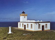
Duncansby Head

Duncansby Head Lighthouse
|
|
|
Scotland
|
|
| Location | Duncansby Head Scotland United Kingdom |
|---|---|
| Coordinates | 58°38′39″N 3°01′30″W / 58.644039°N 3.025120°WCoordinates: 58°38′39″N 3°01′30″W / 58.644039°N 3.025120°W |
| Year first constructed | 1924 |
| Construction | concrete tower |
| Tower shape | square parallelepiped tower with balcony and lantern |
| Markings / pattern | white tower, black lantern, ochre balcony |
| Height | 11 metres (36 ft) |
| Focal height | 67 metres (220 ft) |
| Light source | mains power |
| Intensity | 596,000 candela |
| Range | 22 nautical miles (41 km; 25 mi) |
| Characteristic | Fl W 12s. |
| Admiralty number | A3558 |
| NGA number | 3016 |
| ARLHS number | SCO-062 |
| Managing agent | Northern Lighthouse Board |
Duncansby Head (Scottish Gaelic: Ceann Dhunngain or Dùn Gasbaith) is the most north-easterly part of the Scottish mainland, including even the famous John o' Groats, Caithness, Highland. The headland juts into the North Sea, with the Pentland Firth to its north and west and the Moray Firth to its south.
The point is marked by Duncansby Head Lighthouse, built by David Alan Stevenson in 1924.
A minor public road leads from John o' Groats to Duncansby Head, which makes Duncansby Head the farthest point by road from Land's End.
The Duncansby Head Site of Special Scientific Interest includes the 6.5 km stretch of coast south to Skirza Head. It includes the Duncansby Stacks, prominent sea stacks just off the coast.
...
Wikipedia

