Moose Pass, Alaska
| Moose Pass, Alaska | |
|---|---|
| CDP | |

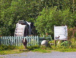
Water wheel and grindstone by side of Seward Highway. The sign reads: "Moose Pass is a peaceful little town, if you have an axe to grind, do it here."
|
|
 Location of Moose Pass, Alaska |
|
| Coordinates: 60°29′16″N 149°22′15″W / 60.48778°N 149.37083°WCoordinates: 60°29′16″N 149°22′15″W / 60.48778°N 149.37083°W | |
| Country | United States |
| State | Alaska |
| Borough | Kenai Peninsula |
| Government | |
| • Borough mayor | Mike Navarre |
| • State senator | Peter Micciche (R) |
| • State rep. | Mike Chenault (R) |
| Area | |
| • Total | 18.1 sq mi (46.9 km2) |
| • Land | 18.0 sq mi (46.7 km2) |
| • Water | 0.1 sq mi (0.2 km2) |
| Elevation | 472 ft (144 m) |
| Population (2010) | |
| • Total | 219 |
| • Density | 12/sq mi (4.7/km2) |
| Time zone | Alaska (AKST) (UTC-9) |
| • Summer (DST) | AKDT (UTC-8) |
| ZIP code | 99631 |
| Area code(s) | 907 |
| FIPS code | 02-50190 |
| GNIS feature ID | 1417076 |
Moose Pass is a census-designated place (CDP) in Kenai Peninsula Borough, Alaska, United States. The population was 219 at the 2010 census.
Moose Pass is located at 60°29′16″N 149°22′15″W / 60.48778°N 149.37083°W (60.487778, -149.370833). Surrounded by the Chugach National Forest, it is located 100 miles south of Anchorage by road, and 30 miles north of Seward on the Seward Highway along Upper Trail Lake.
According to the United States Census Bureau, the CDP has a total area of 18.1 square miles (47 km2), of which 18.0 square miles (47 km2) is land and 0.1 square miles (0.26 km2) (0.33%) is water.
Moose Pass has a dry-summer continental subarctic climate (Köppen Dsc).
As of the census of 2000, there were 206 people, 84 households, and 51 families residing in the CDP. The population density was 11.4 people per square mile (4.4/km²). There were 119 housing units at an average density of 6.6/sq mi (2.5/km²). The racial makeup of the CDP was 87.38% White, 1.46% Black or African American, 5.83% Native American, and 5.34% from two or more races. Hispanic or Latino of any race were 0.49% of the population.
...
Wikipedia
