Montgomery County, Alabama
| Montgomery County, Alabama | |
|---|---|

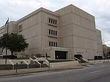
The Montgomery County Courthouse
|
|
 Location in the U.S. state of Alabama |
|
 Alabama's location in the U.S. |
|
| Founded | December 6, 1816 |
| Named for | Lemuel P. Montgomery |
| Seat | Montgomery |
| Largest city | Montgomery |
| Area | |
| • Total | 800 sq mi (2,072 km2) |
| • Land | 784 sq mi (2,031 km2) |
| • Water | 16 sq mi (41 km2), 2.0% |
| Population (est.) | |
| • (2015) | 226,519 |
| • Density | 289/sq mi (112/km²) |
| Congressional districts | 2nd, 3rd, 7th |
| Time zone | Central: UTC-6/-5 |
| Website | www |
|
Footnotes:
|
|
Footnotes:
Montgomery County is a county in the State of Alabama. As of the 2010 census, its population was 229,363, making it the fourth-most populous county in Alabama. Its county seat is Montgomery, the state capital.
Montgomery County is included in the Montgomery, AL Metropolitan Statistical Area.
Montgomery County was established by dividing Monroe County on December 6, 1816, by the Mississippi Territorial Legislature. It is named for Lemuel P. Montgomery, a young U.S. Army officer killed at the Battle of Horseshoe Bend, the final battle of the Creek Indian war, which was waged concurrently with the War of 1812.
The city of Montgomery, which is the county seat, is named for Richard Montgomery, an American Revolutionary War general killed in 1775 while attempting to capture Quebec City, Canada.
According to the U.S. Census Bureau, the county has a total area of 800 square miles (2,100 km2), of which 784 square miles (2,030 km2) is land and 16 square miles (41 km2) (2.0%) is water.
The 2010 United States Census reported the following county population:
...
Wikipedia
