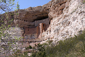
Montezuma Castle National Monument
| Montezuma Castle National Monument | |
|---|---|
|
IUCN category V (protected landscape/seascape)
|
|
 |
|
| Location | Yavapai County, Arizona, USA |
| Nearest city | Prescott, Arizona |
| Coordinates | 34°36′40″N 111°50′02″W / 34.611°N 111.834°WCoordinates: 34°36′40″N 111°50′02″W / 34.611°N 111.834°W |
| Area | 859.27 acres (347.73 ha) |
| Created | December 8, 1906 |
| Visitors | 573,731 (in 2011) |
| Governing body | National Park Service |
| Website | Montezuma Castle National Monument |
| Designated | October 15, 1966 |
| Reference no. | 66000082 |
Montezuma Castle National Monument protects a set of well-preserved Ancestral Puebloan cliff dwellings near the town of Camp Verde, Arizona, United States. The dwellings were built and used by the Sinagua people, a pre-Columbian culture closely related to the Hohokam and other indigenous peoples of the southwestern United States, between approximately 1100 and 1425 AD. The main structure comprises five stories and twenty rooms, and was built over the course of three centuries.
Neither part of the monument's name is correct. When European-Americans first observed the ruins in the 1860s, by then long-abandoned, they named them for the famous Aztec emperor Montezuma in the mistaken belief that he had been connected to their construction (see also Montezuma mythology). In fact, the dwelling was abandoned more than 40 years before Montezuma was born, and was not a "castle" in the traditional sense, but instead functioned more like a "prehistoric high rise apartment complex".
Several Hopi clans and Yavapai communities trace their ancestries to early immigrants from the Montezuma Castle/Beaver Creek area. Clan members periodically return to these ancestral homes for religious ceremonies.
Montezuma Castle is situated about 90 feet (27 m) up a sheer limestone cliff, facing the adjacent Beaver Creek, which drains into the perennial Verde River just north of Camp Verde. It is one of the best-preserved cliff dwellings in North America, in part because of its ideal placement in a natural alcove that protects it from exposure to the elements. The precariousness of the dwelling's location and its immense scale - almost 4,000 square feet (370 m2) of floor space across five stories - suggest that the Sinagua were daring builders and skilled engineers. Access into the structure was most likely permitted by a series of portable ladders, which made it difficult for enemy tribes to penetrate the natural defense of the vertical barrier.
...
Wikipedia

