Montelaterone
| Montelaterone | |
|---|---|
| Frazione | |

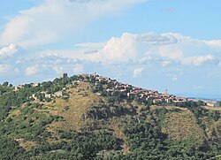
View of Montelaterone from Zancona
|
|
| Location of Montelaterone in Italy | |
| Coordinates: 42°53′15″N 11°30′45″E / 42.88750°N 11.51250°ECoordinates: 42°53′15″N 11°30′45″E / 42.88750°N 11.51250°E | |
| Country |
|
| Region |
|
| Province | Grosseto (GR) |
| Comune | Arcidosso |
| Elevation | 670 m (2,200 ft) |
| Population (2001) | |
| • Total | 283 |
| Demonym(s) | Montelateronesi |
| Time zone | CET (UTC+1) |
| • Summer (DST) | CEST (UTC+2) |
| Postal code | 58030 |
| Dialing code | 0564 |
Montelaterone (Italian: [ˌmontelateˈroːne]) is a village in Tuscany, central Italy, administratively a frazione of the comune of Arcidosso, province of Grosseto, in the area of Mount Amiata. At the time of the 2001 census its population amounted to 283.
Montelaterone is about 52 km from Grosseto and 4 km from Arcidosso, and it is situated on a sandstone peak between the valleys of Ente and Zancona rivers.
...
Wikipedia

