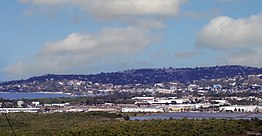
Montego Bay, Jamaica
| Montego Bay | |
|---|---|

View of Montego Bay from the hillside
|
|
| Coordinates: 18°28′N 77°55′W / 18.467°N 77.917°WCoordinates: 18°28′N 77°55′W / 18.467°N 77.917°W | |
| Country |
|
| County | Cornwall |
| Parish | St. James |
| Proclaimed city by act of Parliament | 1980 |
| Government | |
| • Mayor | Homer Davis |
| Population (2011) | |
| • Total | 110,115 |
| • St. James (2001) | 175,127 |
| Time zone | EST (UTC-5) |
| Area code(s) | +1-876 |
Montego Bay is the capital of the parish of St. James and the fourth largest city in Jamaica by population (after Kingston, Spanish Town and Portmore) and the second by area.
Montego Bay is a tourist destination featuring duty-free shopping, a cruise line terminal and several beaches. The city is served by the Donald Sangster International Airport located on the edge of the city. The city is enclosed in a watershed, drained by several rivers such as the Montego River.
When Christopher Columbus for the first time visited the island in 1494, he named the bay Golfo de Buen Tiempo ("Fair Weather Gulf"). The name "Montego Bay" is believed to have originated as a corruption of the Spanish word manteca ("lard"), allegedly because during the Spanish period it was the port where lard, leather, and beef were exported. Jamaica was a colony of Spain from 1511 until 1655, when Oliver Cromwell's Caribbean expedition, the Western Design, drove the Spanish from the island.
During the epoch of slavery, from the mid-17th century until 1834, and well into the 20th century, the town functioned primarily as a sugarcane port. The island's last major slave revolt, the Christmas Rebellion or Baptist War (1831–1832) took place in the area around Montego Bay; the leader of the revolt, Samuel Sharpe, was hanged there in 1832. In 1975, Sharpe was proclaimed a national hero of Jamaica, and the main square of the town was renamed in his honor.
...
Wikipedia

