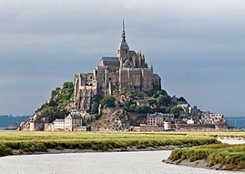
Mont St. Michel
| Le Mont Saint-Michel | ||
|---|---|---|
| Commune | ||
 |
||
|
||
| Coordinates: 48°38′10″N 1°30′41″W / 48.636°N 1.5114°WCoordinates: 48°38′10″N 1°30′41″W / 48.636°N 1.5114°W | ||
| Country | France | |
| Region | Normandy | |
| Department | Manche | |
| Arrondissement | Avranches | |
| Canton | Pontorson | |
| Intercommunality | Pontorson - Le Mont-Saint-Michel | |
| Government | ||
| • Mayor (2014-2020) | Yann Galton | |
| Area1 | 0.97 km2 (0.37 sq mi) | |
| Population (2009)2 | 44 | |
| • Density | 45/km2 (120/sq mi) | |
| Time zone | CET (UTC+1) | |
| • Summer (DST) | CEST (UTC+2) | |
| INSEE/Postal code | 50353 /50116 | |
| Elevation | 5–80 m (16–262 ft) | |
|
1 French Land Register data, which excludes lakes, ponds, glaciers > 1 km² (0.386 sq mi or 247 acres) and river estuaries. 2Population without double counting: residents of multiple communes (e.g., students and military personnel) only counted once. |
||
| UNESCO World Heritage Site | |
|---|---|
| Location |
Manche, canton of Pontorson, France |
| Coordinates | 48°38′09″N 1°30′37″W / 48.6358°N 1.5103°W |
| Area | 3.97 km2 (42,700,000 sq ft) |
| Criteria | i, iii, vi |
| Reference | 80 |
| Inscription | 1979 (3rd Session) |
| Website | www |
|
[]
|
|
1 French Land Register data, which excludes lakes, ponds, glaciers > 1 km² (0.386 sq mi or 247 acres) and river estuaries.
Le Mont-Saint-Michel (pronounced [lə mɔ̃ sɛ̃ mi.ʃɛl]; Norman: Mont Saint Miché, English: Saint Michael's Mount) is an island commune in Normandy, France. It is located about one kilometre (0.6 miles) off the country's northwestern coast, at the mouth of the Couesnon River near Avranches and is 100 hectares (247 acres) in size. As of 2009[update], the island has a population of 44.
The island has held strategic fortifications since ancient times and since the 8th century AD has been the seat of the monastery from which it draws its name. The structural composition of the town exemplifies the feudal society that constructed it: on top, God, the abbey and monastery; below, the great halls; then stores and housing; and at the bottom, outside the walls, houses for fishermen and farmers.
The commune's position — on an island just 600 metres from land — made it accessible at low tide to the many pilgrims to its abbey, but defensible as an incoming tide stranded, drove off, or drowned would-be assailants. The Mont remained unconquered during the Hundred Years' War; a small garrison fended off a full attack by the English in 1433. The reverse benefits of its natural defence were not lost on Louis XI, who turned the Mont into a prison. Thereafter the abbey began to be used more regularly as a jail during the Ancien Régime.
...
Wikipedia


