Mont-Saint-Éloi
| Mont-Saint-Éloi | ||
|---|---|---|
| Commune | ||

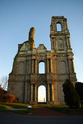
Abbey of Mont Saint-Éloi
|
||
|
||
| Coordinates: 50°21′07″N 2°41′38″E / 50.3519°N 2.6939°ECoordinates: 50°21′07″N 2°41′38″E / 50.3519°N 2.6939°E | ||
| Country | France | |
| Region | Hauts-de-France | |
| Department | Pas-de-Calais | |
| Arrondissement | Arras | |
| Canton | Arras-1 | |
| Intercommunality | Artois | |
| Government | ||
| • Mayor (2008–2014) | Jean-Pierre Bavière | |
| Area1 | 15.85 km2 (6.12 sq mi) | |
| Population (2006)2 | 1,033 | |
| • Density | 65/km2 (170/sq mi) | |
| Time zone | CET (UTC+1) | |
| • Summer (DST) | CEST (UTC+2) | |
| INSEE/Postal code | 62589 /62144 | |
| Elevation | 67–145 m (220–476 ft) (avg. 135 m or 443 ft) |
|
|
1 French Land Register data, which excludes lakes, ponds, glaciers > 1 km² (0.386 sq mi or 247 acres) and river estuaries. 2Population without double counting: residents of multiple communes (e.g., students and military personnel) only counted once. |
||
1 French Land Register data, which excludes lakes, ponds, glaciers > 1 km² (0.386 sq mi or 247 acres) and river estuaries.
Mont-Saint-Éloi is a commune in the Pas-de-Calais department in the Hauts-de-France region of France.
Mont-Saint-Éloi is situated 5 miles (8 km) northwest of Arras, at the junction of the D341 and the D49 roads, on the banks of the river Scarpe.
The menhirs
Menhirs
Écoivres village
Features on the church spire
Aerial view of the countryside
Aerial view
Aerial view of the abbey
...
Wikipedia


