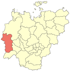
Mirninsky District
| Mirninsky District Мирнинский улус (Russian) Мирнэй улууһа (Yakut) |
|
|---|---|
 Location of Mirninsky District in the Sakha Republic |
|
| Coordinates: 62°32′N 113°57′E / 62.533°N 113.950°ECoordinates: 62°32′N 113°57′E / 62.533°N 113.950°E | |
 View of the town of Mirny, the administrative center of the district |
|
|
|
|
| Location | |
| Country | Russia |
| Federal subject | Sakha Republic |
| Administrative structure (as of June 2009) | |
| Administrative center | town of Mirny |
| Administrative divisions: | |
| Towns | 2 |
| Settlements | 4 |
| Rural okrugs | 3 |
| Inhabited localities: | |
| Cities/towns | 2 |
| Urban-type settlements | 4 |
| Rural localities | 8 |
| Municipal structure (as of December 2008) | |
| Municipally incorporated as | Mirninsky Municipal District |
| Municipal divisions: | |
| Urban settlements | 6 |
| Rural settlements | 3 |
| Statistics | |
| Area (June 2009) | 165,800 km2 (64,000 sq mi) |
| Population (2010 Census) | 38,802 inhabitants |
| • Urban | 92.9% |
| • Rural | 7.1% |
| Density | 0.23/km2 (0.60/sq mi) |
| Time zone | YAKT (UTC+09:00) |
| Established | January 12, 1965 |
| Official website | |
| on | |
| 2010 Census | 38,802 |
|---|---|
| 2002 Census | 46,032 |
| 1989 Census | 51,824 |
| 1979 Census | 29,394 |
Mirninsky District (Russian: Ми́рнинский улу́с; Yakut: Мирнэй улууһа, Mirney uluuha) is an administrative and municipal district (raion, or ulus), one of the thirty-four in the Sakha Republic, Russia. It is located in the west of the republic and borders Olenyoksky District in the north and northeast, Nyurbinsky and Suntarsky Districts in the east, Lensky District in the south, and Irkutsk Oblast and Krasnoyarsk Krai in the west. The area of the district is 165,800 square kilometers (64,000 sq mi). Its administrative center is the town of Mirny. As of the 2010 Census, the total population of the district (excluding its administrative center) was 38,802.
The Vilyuy is the main river in the district.
Average January temperature ranges from −32 °C (−26 °F) in the south to −40 °C (−40 °F) in the north. July's average temperature ranges from +14 °C (57 °F) to +16 °C (61 °F). The average annual precipitation is about 250–300 millimeters (9.8–11.8 in).
The Vilyuy River basin was believed to contain mineral deposits at least as early as the 19th century, with Richard Maack reporting after an expedition to the area that the area was rich in iron, salt deposits, and precious stones. He described a nest of blue clay in the area between the Vilyuy and Malaya Bituobiya Rivers, but as kimberlites had not yet been discovered there was no official attention.
...
Wikipedia


