Minneapolis Warehouse Historic District
|
North Loop Market Square, Market District |
|
|---|---|
| Neighborhood | |
| Nickname(s): The Warehouse District | |
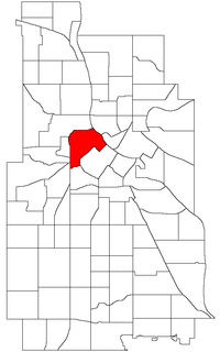
 Location of North Loop within the U.S. city of Minneapolis |
|
| Country | United States |
| State | Minnesota |
| County | Hennepin |
| City | Minneapolis |
| Community | Central |
| Area | |
| • Total | 0.837 sq mi (2.17 km2) |
| Population (2010) | |
| • Total | 4,291 |
| • Density | 5,100/sq mi (2,000/km2) |
| Time zone | CST (UTC-6) |
| • Summer (DST) | CDT (UTC-5) |
| ZIP code | 55401, 55403, 55405, 55411 |
| Area code(s) | 612 |
|
Minneapolis Warehouse Historic District
|
|

A look down First Avenue in the Warehouse District.
|
|
| Location | Minneapolis, Minnesota |
|---|---|
| Coordinates | 44°59′13″N 93°16′35″W / 44.98694°N 93.27639°WCoordinates: 44°59′13″N 93°16′35″W / 44.98694°N 93.27639°W |
| Architect | Multiple |
| Architectural style | Classical Revival, Other, Romanesque |
| NRHP Reference # | 89001937 |
| Added to NRHP | November 3, 1989 |
The North Loop is a neighborhood of the Central community of Minneapolis, Minnesota. The neighborhood is commonly known as the Warehouse District from the city's shipping hub years. It includes the Minneapolis Warehouse Historic District which is listed on the National Register of Historic Places. The North Loop is located just northwest of the central business district between downtown Minneapolis and the Mississippi River. Streets in the North Loop are oriented to be parallel to the river, which means that they run at a 45-degree angle relative to the grid of the rest of the city.
Although the extent of the neighborhood technically extends further to the south, the main residential and commercial area of the North Loop is roughly a rectangle bounded by Hennepin Avenue (in the southeast), Plymouth Avenue (in the northwest), the elevated 4th street freeway entrance/exit in the southwest, and the Mississippi River in the northeast. Washington Avenue is the main thoroughfare through the neighborhood.
The James I. Rice Park, which is in the northeast portion of the neighborhood along the river, is popular with residents during the summer months. The bike trail and West River Parkway that runs through the park are part of the Grand Rounds Scenic Byway. The park added a playground in 2010 located where 4th Ave North intersects with West River Parkway.
For most of its history, the North Loop was an industrial area. It was home to a large railroad yard and numerous warehouses and factories. Much of the warehouse district (very roughly bounded by Second Street North, First Avenue North, Sixth Street North, and the BNSF Railway tracks, except for the Interstate 394 and Interstate 94 ramps) is listed on the National Register of Historic Places.
...
Wikipedia


