Mingoval
| Mingoval | ||
|---|---|---|
| Commune | ||

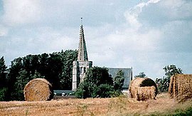
The church of Mingoval
|
||
|
||
| Coordinates: 50°22′31″N 2°34′32″E / 50.3753°N 2.5756°ECoordinates: 50°22′31″N 2°34′32″E / 50.3753°N 2.5756°E | ||
| Country | France | |
| Region | Hauts-de-France | |
| Department | Pas-de-Calais | |
| Arrondissement | Arras | |
| Canton | Avesnes-le-Comte | |
| Intercommunality | Communauté de communes de l'Atrébatie | |
| Government | ||
| • Mayor (2008–2014) | Jacques Deneux | |
| Area1 | 3.79 km2 (1.46 sq mi) | |
| Population (2006)2 | 206 | |
| • Density | 54/km2 (140/sq mi) | |
| Time zone | CET (UTC+1) | |
| • Summer (DST) | CEST (UTC+2) | |
| INSEE/Postal code | 62574 /62690 | |
| Elevation | 109–157 m (358–515 ft) (avg. 125 m or 410 ft) |
|
|
1 French Land Register data, which excludes lakes, ponds, glaciers > 1 km² (0.386 sq mi or 247 acres) and river estuaries. 2Population without double counting: residents of multiple communes (e.g., students and military personnel) only counted once. |
||
1 French Land Register data, which excludes lakes, ponds, glaciers > 1 km² (0.386 sq mi or 247 acres) and river estuaries.
Mingoval is a commune in the Pas-de-Calais department in the Hauts-de-France region of France.
Mingoval is situated 12 miles (19 km) northwest of Arras, on the D73 road.
Ancient entrance to the old farm
The churchyard entrance
The church spire
Architectural detail
Typical regional houses
The church
...
Wikipedia


