Milnor, North Dakota
| country, North Dakota | |
|---|---|
| City | |
| Motto: "Everything Your Rural Heart Could Desire!" | |
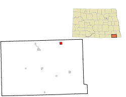
 Location of Milnor, North Dakota |
|
| Coordinates: 46°15′30″N 97°27′21″W / 46.25833°N 97.45583°WCoordinates: 46°15′30″N 97°27′21″W / 46.25833°N 97.45583°W | |
| Country | United States |
| State | North Dakota |
| County | Sargent |
| Area | |
| • Total | 1.01 sq mi (2.62 km2) |
| • Land | 0.94 sq mi (2.43 km2) |
| • Water | 0.07 sq mi (0.18 km2) |
| Elevation | 1,102 ft (336 m) |
| Population (2010) | |
| • Total | 653 |
| • Estimate (2016) | 644 |
| • Density | 650/sq mi (250/km2) |
| Time zone | Central (CST) (UTC-6) |
| • Summer (DST) | CDT (UTC-5) |
| ZIP code | 58060 |
| Area code(s) | 701 |
| FIPS code | 38-52940 |
| GNIS feature ID | 1035008 |
| Website | City of Milnor, North Dakota |
Milnor is a city in Sargent County, North Dakota, United States. The population was 653 at the 2010 census.
Milnor was founded in 1883, and was officially named in 1883. The city was named after William Edward Milnor, the first telegrapher at the Milnor Station, and WM Milnor Roberts, a famous civil engineer.
Milnor is located at 46°15′30″N 97°27′21″W / 46.25833°N 97.45583°W (46.258208, -97.455834).
According to the United States Census Bureau, the city has a total area of 1.01 square miles (2.62 km2), of which, 0.94 square miles (2.43 km2) is land and 0.07 square miles (0.18 km2) is water.
As of the census of 2010, there were 653 people, 289 households, and 189 families residing in the city. The population density was 694.7 inhabitants per square mile (268.2/km2). There were 350 housing units at an average density of 372.3 per square mile (143.7/km2). The racial makeup of the city was 98.6% White, 0.5% Native American, 0.2% from other races, and 0.8% from two or more races. Hispanic or Latino of any race were 0.2% of the population.
...
Wikipedia
