Miller Place, New York
| Miller Place, New York | |
|---|---|
| Hamlet and census-designated place | |

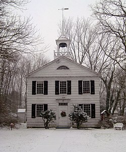
The historic Academy Schoolhouse of Miller Place
|
|
 U.S. Census map |
|
| U.S. Census map | |
| Coordinates: 40°56′48″N 72°59′35″W / 40.94667°N 72.99306°WCoordinates: 40°56′48″N 72°59′35″W / 40.94667°N 72.99306°W | |
| Country | United States |
| State | New York |
| County | Suffolk |
| Area | |
| • Total | 6.6 sq mi (17.0 km2) |
| • Land | 6.6 sq mi (17.0 km2) |
| • Water | 0.0 sq mi (0.0 km2) |
| Elevation | 131 ft (40 m) |
| Population (2010) | |
| • Total | 12,339 |
| • Density | 1,900/sq mi (730/km2) |
| Time zone | Eastern (EST) (UTC-5) |
| • Summer (DST) | EDT (UTC-4) |
| ZIP code | 11764 |
| Area code(s) | 631 |
| FIPS code | 36-47306 |
| GNIS feature ID | 0957319 |
Miller Place is a hamlet and census-designated place (CDP) in Suffolk County, New York, United States, on the North Shore of Long Island. Miller Place has been inhabited since the 17th century and is named for the Miller family that included many of its initial settlers. For most of its history, the community functioned as an agriculture-based society. Despite preserving much of its historic identity, changes in the 20th century have transitioned the hamlet into a desirable and densely populated suburban area. The population was 12,339 at the 2010 census.
The land that Miller Place occupies was purchased from the native Setalcott tribe in 1664 by settlers of Setauket. The parcel also included what would become Mount Sinai, New York, an adjacent community of similar character with which Miller Place would share a variety of functions throughout its history.
The first known dwelling in the area was constructed in the 1660s by Captain John Scott, an important figure in Long Island's early history. This house was named Braebourne and features on a map of the New England region credited to Scott, who served as a royal advisor and cartographer among other occupations. This abode, on the eastern side of Mount Sinai Harbor, was one of three houses John Scott commissioned, and the actual occupier is unknown.
While the original settler of Miller Place is unknown, the settling of the region is largely accredited to the original Miller family. In 1679, an East Hampton settler named Andrew Miller purchased a 30-acre (120,000 m2) plot. Miller was a cooper by profession, and records indicate that he had emigrated from either Maidstone, England or Craigmillar, Scotland.
By the early 1700s, the community had become known as Miller's Place. The Miller family expanded well into the 18th century and continually developed houses in the northern part of the hamlet. The Millers were in time joined by members of such families as the Helmes, Robinsons, Burnetts, Hawkins, Woodhulls, and Thomases. Many roads in the present hamlet have been named after historical families.
...
Wikipedia

