Mike O'Callaghan–Pat Tillman Memorial Bridge
| Mike O'Callaghan–Pat Tillman Memorial Bridge | |
|---|---|

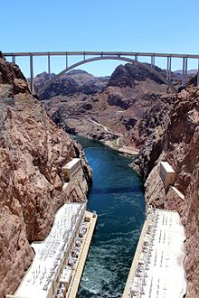
The bridge as seen from the Hoover Dam
|
|
| Coordinates | 36°0′45″N 114°44′29″W / 36.01250°N 114.74139°WCoordinates: 36°0′45″N 114°44′29″W / 36.01250°N 114.74139°W |
| Carries |
|
| Crosses | Colorado River |
| Locale |
Lake Mead National Recreation Area, Clark County, Nevada – Mohave County, Arizona |
| Official name | Mike O'Callaghan–Pat Tillman Memorial Bridge |
| Other name(s) | Hoover Dam Bypass Bridge |
| Maintained by |
Arizona Department of Transportation (ADOT) Nevada Department of Transportation (NDOT) |
| Characteristics | |
| Design | concrete-steel composite arch bridge |
| Total length | 1,900 feet (579 m) |
| Longest span | 1,060 ft (323 m) |
| Clearance below | 900 ft (270 m) |
| History | |
| Designer | Bridge Designer T.Y. Lin International Design Manager HDR, Inc. |
| Construction begin | February 14, 2005 |
| Construction end | October 14, 2010 |
| Construction cost | $240 million |
| Opened | October 16, 2010 (to pedestrians); October 19, 2010 (regular traffic) |
| Statistics | |
| Daily traffic | 15,000 |
The Mike O'Callaghan–Pat Tillman Memorial Bridge is an arch bridge in the United States that spans the Colorado River between the states of Arizona and Nevada. The bridge is located within the Lake Mead National Recreation Area approximately 30 miles (48 km) southeast of Las Vegas, and carries U.S. Route 93 over the Colorado River. Opened in 2010, it was the key component of the Hoover Dam Bypass project, which rerouted US 93 from its previous routing along the top of Hoover Dam and removed several hairpin turns and from the route. It is jointly named for Mike O'Callaghan, Governor of Nevada from 1971–1979, and Pat Tillman, an American football player who left his career with the Arizona Cardinals to enlist in the United States Army and was later killed in Afghanistan by friendly fire.
As early as the 1960s, officials identified the US 93 route over Hoover Dam to be dangerous and inadequate for projected traffic volumes. From 1998–2001, officials from Arizona, Nevada, and several federal government agencies collaborated to determine the best routing for an alternative river crossing. In March 2001, the Federal Highway Administration selected the route, which crosses the Colorado River approximately 1,500 feet (460 m) downstream of Hoover Dam. Construction of the bridge approaches began in 2003, and construction of the bridge itself began in February 2005. The bridge was completed in 2010 and the entire bypass route opened to vehicle traffic on October 19, 2010. The Hoover Dam Bypass project was completed within budget at a cost of $240 million; the bridge portion cost $114 million.
...
Wikipedia
