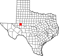
Midland County, Texas
| Midland County, Texas | ||
|---|---|---|

The Midland County Courthouse in Midland
|
||
|
||
 Location in the U.S. state of Texas |
||
 Texas's location in the U.S. |
||
| Founded | 1885 | |
| Seat | Midland | |
| Largest city | Midland | |
| Area | ||
| • Total | 902 sq mi (2,336 km2) | |
| • Land | 900 sq mi (2,331 km2) | |
| • Water | 1.8 sq mi (5 km2), 0.2% | |
| Population | ||
| • (2015) | 161,077 | |
| • Density | 152/sq mi (59/km²) | |
| Congressional district | 11th | |
| Time zone | Central: UTC-6/-5 | |
| Website | www |
|
Midland County is a county located in the U.S. state of Texas. As of 2015, the population was 161,077. The county seat is Midland. The county is so named as the county is halfway (midway) between Fort Worth and El Paso on the Texas and Pacific Railway.
Midland County is included in the Midland, TX Metropolitan Statistical Area as well as the Midland–Odessa Combined Statistical Area.
In 1968, the county lost before the Supreme Court in Avery v. Midland County which required local districts to be nearly equal. The city of Midland had most of the county's population but only elected one of the five county commissioners, which was found to violate the Fourteenth Amendment.
According to the U.S. Census Bureau, the county has a total area of 902 square miles (2,340 km2), of which 900 square miles (2,300 km2) is land and 1.8 square miles (4.7 km2) (0.2%) is water. The Spraberry Trend, the third-largest oil field in the United States by remaining reserves, underlies much of the county.
As of the census of 2000, there were 116,009 people, 42,745 households, and 30,947 families residing in the county. The population density was 129 people per square mile (50/km²). There were 48,060 housing units at an average density of 53 per square mile (21/km²). The racial makeup of the county was 77.32% White, 6.98% Black or African American, 0.64% Native American, 0.93% Asian, 0.03% Pacific Islander, 12.17% from other races, and 1.92% from two or more races. 29.03% of the population were Hispanic or Latino of any race.
...
Wikipedia

