Midland, Pennsylvania
| Midland, Pennsylvania | |
|---|---|
| Borough | |

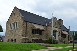
Carnegie library
|
|
 Location in Beaver County and state of Pennsylvania |
|
| Coordinates: 40°38′18″N 80°27′09″W / 40.63833°N 80.45250°WCoordinates: 40°38′18″N 80°27′09″W / 40.63833°N 80.45250°W | |
| Country | United States |
| State | Pennsylvania |
| County | Beaver |
| Incorporated | 1906 |
| Government | |
| • Type | Borough Council |
| Area | |
| • Total | 2.0 sq mi (5.2 km2) |
| • Land | 1.8 sq mi (4.7 km2) |
| • Water | 0.2 sq mi (0.5 km2) |
| Elevation | 797 ft (243 m) |
| Population (2010) | |
| • Total | 2,635 |
| • Density | 1,457/sq mi (562.4/km2) |
| Time zone | Eastern (EST) (UTC-5) |
| • Summer (DST) | EDT (UTC-4) |
| Zip code | 15059 |
| Area code(s) | 724 |
Midland is a borough located along the Ohio River in Beaver County, Pennsylvania, United States. As of the 2010 census, the borough population was 2,635, down from 3,137 in 2000.
Midland is located in western Beaver County at 40°38′18″N 80°27′9″W / 40.63833°N 80.45250°W (40.638273, -80.452455). It is bordered to the northwest by Ohioville and to the northeast by Industry. To the southeast, across the Ohio River, is the borough of Shippingport, and Greene Township is to the southwest. Pennsylvania Route 68 (Midland Avenue) is the main street through the community, leading east into Industry and west to Glasgow and the Ohio border. Pennsylvania Route 168 joins PA-68 along Midland Avenue through the center of town, but splits off to the south to cross the Ohio River via the Shippingport Bridge, and climbs out of the river valley to the north via Fairview Road.
According to the United States Census Bureau, the borough has a total area of 2.0 square miles (5.2 km2), of which 1.8 square miles (4.7 km2) is land and 0.19 square miles (0.5 km2), or 9.13%, is water.
...
Wikipedia
