Middle Smithfield Township, Pennsylvania
| Middle Smithfield Township | |
|---|---|

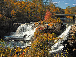
Resica Falls in Middle Smithfield Township
|
|
 Location of Pennsylvania in the United States |
|
| Coordinates: 41°05′00″N 74°59′35″W / 41.08333°N 74.99306°WCoordinates: 41°05′00″N 74°59′35″W / 41.08333°N 74.99306°W | |
| Country | United States |
| State | Pennsylvania |
| County | Monroe |
| Area | |
| • Total | 54.23 sq mi (140.46 km2) |
| • Land | 53.16 sq mi (137.68 km2) |
| • Water | 1.07 sq mi (2.78 km2) |
| Elevation | 636 ft (194 m) |
| Population (2010) | |
| • Total | 15,997 |
| • Estimate (2016) | 15,647 |
| • Density | 294.34/sq mi (113.65/km2) |
| Time zone | EST (UTC-5) |
| • Summer (DST) | EDT (UTC-4) |
| Area code(s) | 570 |
| FIPS code | 42-089-49080 |
| Website | www |
Middle Smithfield Township is a township in Monroe County, Pennsylvania, United States. The population was 11,495 at the 2000 census. 2008 population estimates by the United States Census Bureau place the population at 14,900.
The Cold Spring Farm Springhouse, John Michael Farm, Schoonover Mountain House, Capt. Jacob Shoemaker House, John Turn Farm, Zion Lutheran Church are located in Delaware Water Gap National Recreation Area at Middle Smithfield Township and listed on the National Register of Historic Places.
According to the United States Census Bureau, the township has a total area of 54.2 square miles (140.2 km2), of which, 53.1 square miles (137.6 km2) of it is land and 1.0 square miles (2.6 km2) of it (1.88%) is water.
As of the census of 2000, there were 11,495 people, 3,973 households, and 3,031 families residing in the township. The population density was 216.3 people per square mile (83.5/km2). There were 6,021 housing units at an average density of 113.3/sq mi (43.8/km2). The racial makeup of the township was 85.24% White, 7.66% African American, 0.22% Native American, 1.31% Asian, 0.01% Pacific Islander, 3.18% from other races, and 2.38% from two or more races. Hispanic or Latino of any race were 8.61% of the population.
...
Wikipedia
