Melito Irpino
| Melito Irpino | |
|---|---|
| Comune | |
| Comune di Melito Irpino | |

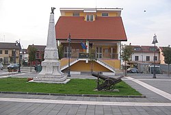
Melito town hall
|
|
 Melito Irpino within the Province of Avellino |
|
| Location of Melito Irpino in Italy | |
| Coordinates: 41°6′15″N 15°3′12″E / 41.10417°N 15.05333°ECoordinates: 41°6′15″N 15°3′12″E / 41.10417°N 15.05333°E | |
| Country | Italy |
| Region | Campania |
| Province / Metropolitan city | Avellino (AV) |
| Frazioni | Cozza, Fontana del Bosco, Incoronata |
| Area | |
| • Total | 20.71 km2 (8.00 sq mi) |
| Elevation | 450 m (1,480 ft) |
| Population (2011) | |
| • Total | 1,936 |
| • Density | 93/km2 (240/sq mi) |
| Demonym(s) | Melitesi |
| Time zone | CET (UTC+1) |
| • Summer (DST) | CEST (UTC+2) |
| Postal code | 83030 |
| Dialing code | 0825 |
| Patron saint | Saint Giles |
| Saint day | 1 September |
| Website | Official website |
Melito Irpino is a town and comune in the province of Avellino, in the Campania region of south-western Italy. As of 2011 its population was of 1,936.
The remains of the ancient Melito were found in 1880. According to some theories, it could be a suburban village belonging to Aeclanum, but the prevailing theory suggests that it was the ancient village of Melae (or Melas). In Ab Urbe Condita (book XXIV, chapter X), Titus Livius wrote that Melae was destroyed in 215 BC by the troops of Claudius Marcellus and Quintus Fabius, during the Second Punic War.
The municipality is located in the nortern area of its province, next to the one of Benevento. Crossed by the river Ufita, it borders with Apice (BN), Ariano Irpino, Bonito and Grottaminarda. Its hamlets (frazioni) are the villages of Cozza, Fontana del Bosco and Incoronata.
The town is 5 km far from Grottaminarda, 9 from Ariano Irpino, 30 from Benevento and 48 from Avellino. Nearest motorway exit is located in Grottaminarda, on the A16 Naples-Bari.
...
Wikipedia

