Mechanicsville, Virginia
| Mechanicsville, Virginia | |
|---|---|
| CDP | |
| Nickname(s): The Ville | |
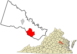
 Location in Hanover County and the state of Virginia. |
|
| Coordinates: 37°37′9″N 77°21′18″W / 37.61917°N 77.35500°WCoordinates: 37°37′9″N 77°21′18″W / 37.61917°N 77.35500°W | |
| Country | United States |
| State | Virginia |
| County | Hanover |
| Area | |
| • Total | 28.5 sq mi (73.8 km2) |
| • Land | 28.4 sq mi (73.6 km2) |
| • Water | 0.1 sq mi (0.3 km2) |
| Population (2010) | |
| • Total | 36,348 |
| • Density | 1,300/sq mi (490/km2) |
| Time zone | Eastern (EST) (UTC-5) |
| • Summer (DST) | EDT (UTC-4) |
| Area code(s) | 804 |
Mechanicsville is a census-designated place (CDP) in Hanover County, Virginia, United States. The population was 36,348 during the 2010 census.
The area was settled by English colonists starting in the 17th century. Rural Plains, also known as Shelton House, is a house built in the early decades of the eighteenth century. It is now owned and operated by the National Park Service as one of the sites of the Richmond National Battlefield Park.
In "Old Mechanicsville" stands a stone windmill, now a landmark in the village. The building was constructed as a "Heritage Bank" branch office in the 1970s. In 2007-2008, it was restored and enlarged by a new bank occupancy. The "windmill" is decorative and driven by an electric motor.
Mechanicsville is associated with several major battles and numerous minor skirmishes during the American Civil War.
In addition to Rural Plains, Clover Lea, Cold Harbor National Cemetery, Cool Well, Hanover Meeting House, Hanover Town, Immanuel Episcopal Church, Laurel Meadow, Locust Hill, Oak Forest, Oakley Hill, Selwyn, and Spring Green are listed on the National Register of Historic Places.
...
Wikipedia
