McDade, Texas
| McDade, Texas | |
|---|---|
| Census-designated place | |

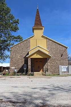
McDade Baptist Church
|
|
| Location within the state of Texas | |
| Coordinates: 30°17′02″N 97°14′16″W / 30.28389°N 97.23778°WCoordinates: 30°17′02″N 97°14′16″W / 30.28389°N 97.23778°W | |
| Country | United States |
| State | Texas |
| County | Bastrop |
| Area | |
| • Total | 4.0 sq mi (10 km2) |
| • Land | 4.0 sq mi (10 km2) |
| • Water | 0.0 sq mi (0 km2) |
| Elevation | 551 ft (168 m) |
| Population (2010) | |
| • Total | 685 |
| • Density | 170/sq mi (66/km2) |
| Time zone | Central (CST) (UTC-6) |
| • Summer (DST) | CDT (UTC-5) |
| ZIP code | 78650 |
| FIPS code | 48-45564 |
| GNIS feature ID | 1341178 |
McDade is an unincorporated community and census-designated place in northern Bastrop County, Texas, located along U.S. Route 290. As of the 2010 census, it had a population of 685. It is 9 miles (14 km) east of Elgin and 34 miles (55 km) east of Austin. It is 21 miles (34 km) west of Giddings.
This was a new CDP for the 2010 census.
The community is named for James W. McDade, a major stockholder in the Houston and Texas Central Railroad in 1869.
The McDade Independent School District serves area students.
McDade was, for several years, the childhood home of 1950s television and recording star Gale Storm, as her mother owned a millinery shop in McDade.
According to the United States Census Bureau, the CDP has a total area of 4.0 square miles (10 km2), all land.
...
Wikipedia


