Mayville, New York
| Mayville, New York | |
|---|---|
| Village | |

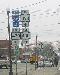
Near the intersection of Routes 430 and 394
|
|
| Location within the state of New York | |
| Coordinates: 42°15′5″N 79°30′0″W / 42.25139°N 79.50000°WCoordinates: 42°15′5″N 79°30′0″W / 42.25139°N 79.50000°W | |
| Country | United States |
| State | New York |
| County | Chautauqua |
| Town | Chautauqua |
| Area | |
| • Total | 2.0 sq mi (5.2 km2) |
| • Land | 2.0 sq mi (5.2 km2) |
| • Water | 0.0 sq mi (0.0 km2) |
| Elevation | 1,453 ft (443 m) |
| Population (2010) | |
| • Total | 1,711 |
| • Density | 859/sq mi (331.8/km2) |
| Time zone | Eastern (EST) (UTC-5) |
| • Summer (DST) | EDT (UTC-4) |
| ZIP code | 14757 |
| Area code(s) | 716 |
| FIPS code | 36-46239 |
| GNIS feature ID | 0956714 |
| Website | villageofmayville |
Mayville is a village in Chautauqua County, New York, United States. The population was 1,709 at the 2010 census, which is down 2.7% from the 2000 census. The Mayville is in the town of Chautauqua and is the county seat of Chautauqua County. The village and town offices share a building on Main Street, directly across from the Chautauqua County courthouse.
The first settlement in the county was at this location in 1804, and the village of Mayville was incorporated in 1830. In 1836 local residents rioted against the Holland Land Company and broke into its office, destroying furniture and papers.
The Pennsylvania Railroad built a train station and pier on the shores of Chautauqua Lake at Mayville. This location, along with the Jamestown boat landing at the south end of the lake, was the main mode of transportation to the rest of the communities around Chautauqua Lake via the large fleet of steamboats operating before the trolley line was constructed. In modern times the steamboat Chautauqua Belle still operates out of Mayville, running between Point Chautauqua, Chautauqua Institution, and the vessel's home port in Mayville.
The Pennsylvania Railroad Station was listed on the National Register of Historic Places in 1993. The Point Chautauqua Historic District was listed in 1996.
Mayville is located near the geographic center of the town of Chautauqua at 42°15′5″N 79°30′0″W / 42.25139°N 79.50000°W (42.251402, -79.500015). It is situated at the northwest end of Chautauqua Lake.
...
Wikipedia

