Mays Landing, New Jersey
| Mays Landing, New Jersey | |
|---|---|
| Census-designated place | |

Main Street in Mays Landing in 2006
|
|
 Map of Mays Landing CDP in Atlantic County. Inset: Location of Atlantic County in New Jersey. |
|
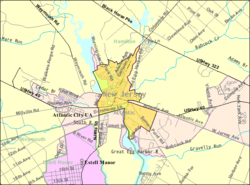
 Census Bureau map of Mays Landing, New Jersey |
|
| Coordinates: 39°27′10″N 74°43′26″W / 39.452862°N 74.723936°WCoordinates: 39°27′10″N 74°43′26″W / 39.452862°N 74.723936°W | |
| Country |
|
| State |
|
| County | Atlantic |
| Township | Hamilton |
| Named for | Captain George May |
| Area | |
| • Total | 1.885 sq mi (4.881 km2) |
| • Land | 1.660 sq mi (4.299 km2) |
| • Water | 0.225 sq mi (0.581 km2) 11.91% |
| Elevation | 13 ft (4 m) |
| Population (2010 Census) | |
| • Total | 2,135 |
| • Density | 1,286.2/sq mi (496.6/km2) |
| Time zone | Eastern (EST) (UTC-5) |
| • Summer (DST) | Eastern (EDT) (UTC-4) |
| ZIP code | 08330 |
| Area code(s) | 609 |
| FIPS code | 3444820 |
| GNIS feature ID | 02390140 |
Mays Landing is an unincorporated community and census-designated place (CDP) located within Hamilton Township, Atlantic County, New Jersey, United States. At the 2010 United States Census, the CDP's population was 2,135. It is the county seat of Atlantic County. The community was named for Captain George May, who sailed the Great Egg Harbor River in 1740, and purchased land in the area in 1756.
According to the United States Census Bureau, Mays Landing had a total area of 1.885 square miles (4.881 km2), including 1.660 square miles (4.299 km2) of land and 0.225 square miles (0.581 km2) of water (11.91%).
The community is located 20 miles (32 km) west of Atlantic City. The community known as Mizpah is located 5 miles (8 km) west of Mays Landing on U.S. Route 40 but is sometimes considered part of it, with ZIP codes of 08330 and 08342. McKee City is an unincorporated area 4 miles (6 km) east of Mays Landing on US 40.
The climate in this area is characterized by hot, humid summers and generally mild to cool winters. According to the Köppen Climate Classification system, Mays Landing has a humid subtropical climate, abbreviated "Cfa" on climate maps.
The 2010 United States Census counted 2,135 people, 859 households, and 572.1 families residing in the CDP. The population density was 1,286.2 per square mile (496.6/km2). The CDP contained 949 housing units at an average density of 571.7 per square mile (220.7/km2). The racial makeup of the CDP was 88.99% (1,900) White, 5.48% (117) Black or African American, 0.47% (10) Native American, 0.98% (21) Asian, 0.00% (0) Pacific Islander, 1.92% (41) from other races, and 2.15% (46) from two or more races. Hispanics or Latinos of any race were 7.26% (155) of the population.
...
Wikipedia
