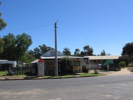
Maude, New South Wales
|
Maude New South Wales |
|
|---|---|

Post office and general store
|
|
| Coordinates | 34°27′0″S 144°18′0″E / 34.45000°S 144.30000°ECoordinates: 34°27′0″S 144°18′0″E / 34.45000°S 144.30000°E |
| Population | 161 (2006 census) |
| Established | 1861 |
| Postcode(s) | 2711 |
| Location | 55 km (34 mi) from Hay |
| LGA(s) | Hay Shire |
| County | Waradgery |
| State electorate(s) | Murray |
| Federal Division(s) | Farrer |
Maude is a village on the north bank of the Murrumbidgee River in New South Wales, Australia. It is in between Hay and Balranald in Hay Shire. It is located 55 kilometres downstream from Hay and 25 kilometres upstream from the junction of the Lachlan River with the Murrumbidgee. At the 2006 census, Maude had a population of 161 people. Maude consists of a General Store, hotel, post office and caravan park. The town is surrounded by market gardens supplied with water from Maude Weir, a popular spot for anglers, looking for yellow belly, redfin and Murray cod.
Maude marks the traditional boundary between the Muthi Muthi and Nari Nari Aboriginal tribes.
The surveyor F. P. McCabe, under instructions from the Colonial Secretary, surveyed a number of reserves on the lower Murrumbidgee River in about 1849. The reserves were finally gazetted in October 1852. They included the "Pin Pan Pa" reserve of 7.5 square miles (19 km2), described as being "situated on cattle runs, occupied by Phelps and Darchey", just over a mile downstream from "the hut at Pin-pan-pa". The reserve was taken from Phelps and Chadwick’s "Pimpampa" and Thomas D'Archy’s "Budgee Budgee" runs. During the 1850s the Pimpampa Reserve was used as a crossing place for stock and drays. Being close to the Lachlan–Murrumbidgee junction the crossing-place was probably used by those who were unwilling to leave the river frontages during hot and dry conditions. Feldtmann (1976) states that a hotel was built at the locality by the late 1850s; if true, it was certainly not licensed and was probably just a bush shanty serving a passing trade and workers on local pastoral runs.
In the early 1860s the surveyors Adams and Twynam laid out a township on the Pimpampa Reserve. The name ‘Pimpaympa’ was submitted, but it was not approved by the Executive Council; instead they chose the name of ‘Maude’.
...
Wikipedia

