Maud, Texas
| Maud, Texas | |
|---|---|
| City | |
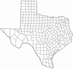
 Location of Maud, Texas |
|
 |
|
| Coordinates: 33°19′56″N 94°20′36″W / 33.33222°N 94.34333°WCoordinates: 33°19′56″N 94°20′36″W / 33.33222°N 94.34333°W | |
| Country | United States |
| State | Texas |
| County | Bowie |
| Area | |
| • Total | 1.5 sq mi (3.9 km2) |
| • Land | 1.5 sq mi (3.9 km2) |
| • Water | 0.0 sq mi (0.0 km2) |
| Elevation | 289 ft (88 m) |
| Population (2010) | |
| • Total | 1,056 |
| • Density | 708/sq mi (273.5/km2) |
| Time zone | Central (CST) (UTC-6) |
| • Summer (DST) | CDT (UTC-5) |
| ZIP code | 75567 |
| Area code(s) | 903 |
| FIPS code | 48-47088 |
| GNIS feature ID | 1374819 |
Maud is a city in Bowie County, Texas, United States. As of the 2010 census it had a population of 1,056. It is part of the Texarkana, Texas - Texarkana, Arkansas Metropolitan Statistical Area.
Maud is located in southern Bowie County at 33°19′56″N 94°20′36″W / 33.33222°N 94.34333°W (33.332185, -94.343244).U.S. Route 67 passes through the center of town, leading northeast 18 miles (29 km) to Texarkana and southwest 43 miles (69 km) to Mount Pleasant. Texas State Highway 8 leads south from Maud 23 miles (37 km) to Linden and north 13 miles (21 km) to New Boston. The city is 4 miles (6 km) north of Wright Patman Lake, a reservoir on the Sulphur River.
According to the United States Census Bureau, the city of Maud has a total area of 1.5 square miles (3.9 km2), all of it land.
As of the census of 2010, there were 1,056 people in the city. The population density was 691.3 people per square mile (266.4/km²). There were 473 housing units at an average density of 318.1/sq mi (122.6/km²). The racial makeup of the city was 90.76% White, 7.59% African American, 0.58% Native American, 0.10% Asian, 0.10% from other races, and 0.88% from two or more races. Hispanic or Latino of any race were 1.36% of the population.
...
Wikipedia
