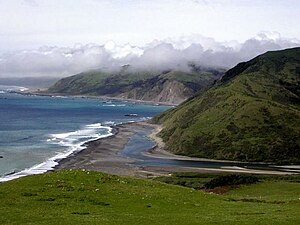
Mattole River
| Mattole River (Mattóal) | |
| stream | |
|
Mattole River Estuary
|
|
| Country | United States |
|---|---|
| State | California |
| Regions | Mendocino County, Humboldt County |
| Cities | Petrolia, Whitethorn, Honeydew |
| Source | King Range |
| - location | 11 mi (18 km) southwest of Redway, California |
| - elevation | 1,780 ft (543 m) |
| - coordinates | 39°59′7″N 123°58′19″W / 39.98528°N 123.97194°W |
| Mouth | Pacific Ocean |
| - location | 4 mi (6 km) west of Petrolia, California |
| - elevation | 0 ft (0 m) |
| - coordinates | 40°18′8″N 124°21′14″W / 40.30222°N 124.35389°WCoordinates: 40°18′8″N 124°21′14″W / 40.30222°N 124.35389°W |
| Length | 62 mi (100 km) |
| Basin | 304 sq mi (787 km2) |
| Discharge | for Petrolia |
| - average | 1,288 cu ft/s (36 m3/s) |
| - max | 90,400 cu ft/s (2,560 m3/s) |
| - min | 11 cu ft/s (0 m3/s) |
The Mattole River is a river on the north coast of California, that flows northerly, then westerly into the Pacific Ocean. The vast majority of its 62 miles (100 km) course is through southern Humboldt County, though a short section of the river flows through northern Mendocino County. Communities, from north to south, closely associated with the Mattole River include: Petrolia, Honeydew, Ettersburg, Thorn Junction, and Whitethorn. The river enters the ocean at the Mattole Estuary about 4 miles (6.4 km) west-southwest of Petrolia and 10 miles (16 km) south of Cape Mendocino.
"Mattole" refers to an Athabaskan Indian people, the Mattole. They historically called themselves Mattóal or bedool, but were called by neighboring Wyott Indians Medol or me'tuul. The Mattole lived principally on the Mattole and Bear rivers. This war-like tribe was practically exterminated because of its resistance to white settlers during the Bald Hills War. The local tradition is that Mattole means "clear water".
The river and its 74 tributaries drain about 304 square miles (790 km2), including the eastern side of the King Range, and flows through Mattole Valley before emptying into the Pacific Ocean. Although the Mattole River's source is at about 1,780 feet (540 m) elevation, its tributaries originate as high as 4,000 feet (1,200 m) above sea level. The North Fork of the Mattole River enters the river main stem just west of Petrolia. For most of its length, the river is only a 4.2 miles (6.8 km) east of the King Range National Conservation Area. About halfway to the ocean, near Honeydew, California, the river passes by Humboldt Redwoods State Park. There are numerous tributaries and creeks that feed the drainage area. Some of the largest are the Upper North Fork at Honeydew (as opposed to the North Fork at Petrolia), Honeydew, Bear, Rattlesnake, and Oil Creeks.
...
Wikipedia

